Kramp
Kramp is a building in Biggleswade, Central Bedfordshire, England. Kramp is situated nearby to the church Saxon Drive Gospel Hall, as well as near Saxon Gate Park.| Tap on a place to explore it |
Places of Interest Nearby
Highlights include Biggleswade railway station and Stratton Upper School.
Biggleswade railway station
Railway station

Photo: Wikimedia, Copyrighted free use.
Biggleswade railway station serves the market town of Biggleswade in Bedfordshire, England. It is on the East Coast Main Line, 41 miles 13 chains from London King's Cross. Biggleswade railway station is situated 1¼ miles northwest of Kramp.
Stratton Upper School
School
Stratton School is a mixed British school and sixth form located in Biggleswade, Bedfordshire. It is an academy school, governed by the Cambridge Meridian Academies Trust. Stratton Upper School is situated 1 mile northwest of Kramp.
Church of St Andrew, Langford, Bedfordshire
Church

Photo: Rodney Burton, CC BY-SA 2.0.
Church of St Andrew is a Grade I listed church in Langford, Bedfordshire, England. It became a listed building on 31 October 1966. The three bells, the oldest of which dates back to 1772, are housed in their original wooden frame. Church of St Andrew, Langford, Bedfordshire is situated 2 miles southwest of Kramp.
Places in the Area
Nearby places include Langford and Dunton.
Langford
Village

Photo: Richard Croft, CC BY-SA 2.0.
Langford is a village and civil parish in the Central Bedfordshire district of the county of Bedfordshire, England about 10 miles south-east of the county town of Bedford. The 2011 census gives the population as 3,091. Langford is situated 2 miles southwest of Kramp.
Dunton
Village

Photo: Rodney Burton, CC BY-SA 2.0.
Dunton is a village and civil parish in the Central Bedfordshire district of the county of Bedfordshire, England; about 12 miles east south-east of the county town of Bedford. The civil parish includes the hamlets of Newton and Millow. Dunton is situated 2 miles east of Kramp.
Hinxworth
Village
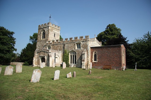
Photo: Richard Croft, CC BY-SA 2.0.
Hinxworth is a village and civil parish in North Hertfordshire, England. It sits just off the Great North Road between Baldock and Biggleswade. It has a village hall, a park, a pub, a small church, a bus stop and a post box. Hinxworth is situated 2½ miles southeast of Kramp.
Kramp
- Type: Building
- Location: Biggleswade, Central Bedfordshire, England, United Kingdom, Britain and Ireland, Europe
- View on OpenStreetMap
Latitude
52.07346° or 52° 4′ 24″ northLongitude
-0.23699° or 0° 14′ 13″ westOpen location code
9C4X3QF7+96OpenStreetMap ID
way 62756819OpenStreetMap feature
building=yes
This page is based on OpenStreetMap, Wikidata, and Wikimedia Commons.
We’d love your help improving our open data sources. Thank you for contributing.
Satellite Map
Discover Kramp from above in high-definition satellite imagery.
Places with the Same Name
Discover other places named “Kramp”.
Notable Places Nearby
Highlights include Saxon Drive Gospel Hall and Saxon Gate Park.
Nearby Places
Explore places such as iCandy and Stratton Business Park.
England: Must-Visit Destinations
Delve into London, Manchester, Sheffield, and Leeds.
Curious Buildings to Discover
Uncover intriguing buildings from every corner of the globe.
About Mapcarta. Data © OpenStreetMap contributors and available under the Open Database License". Text is available under the CC BY-SA 4.0 license, except for photos, directions, and the map. Photo: RobThinks, CC BY-SA 4.0.