Lench’s Close
Lench’s Close is a building in Birmingham, England which is located on Lench’s Close. Lench’s Close is situated nearby to Calvary Church of God in Christ, as well as near War Memorial to the South-East of the Church of St Mary.| Tap on a place to explore it |
Places of Interest Nearby
Highlights include St Mary’s Church, Moseley and War Memorial to the South-East of the Church of St Mary.
St Mary’s Church, Moseley
Church
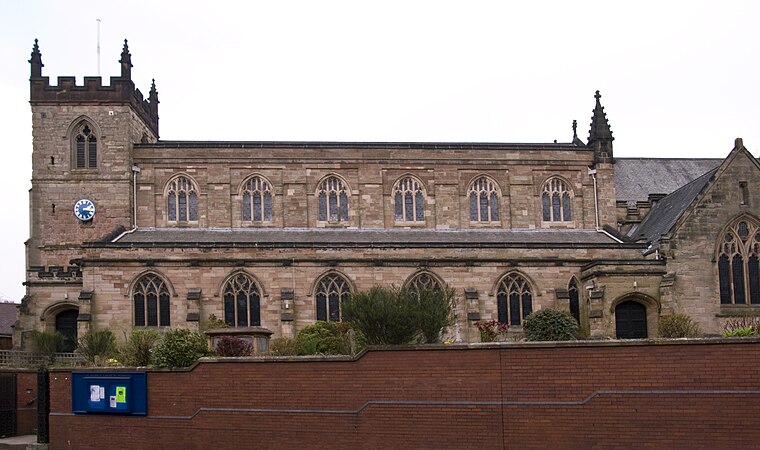
Photo: Oosoom, CC BY-SA 3.0.
St Mary's Church, Moseley is a Grade II listed parish church in the Church of England located in Moseley, Birmingham. It is now part of a united benefice with St Anne's Church, Moseley. St Mary’s Church, Moseley is situated 720 feet northwest of Lench’s Close.
War Memorial to the South-East of the Church of St Mary
Memorial

Photo: Brianboru100, CC BY-SA 3.0.
War Memorial to the South-East of the Church of St Mary is situated 580 feet northwest of Lench’s Close.
Moseley Park
Park

Photo: Basher Eyre, CC BY-SA 2.0.
Moseley Park and Pool is an 11-acre gated park in Moseley, Birmingham, maintained by the Moseley Park and Pool Trust. It is located to the west of the district centre and the A435 Alcester Road; it sits in the Birmingham City Council electoral ward of Moseley and is situated very close to the border with Balsall Heath West. Moseley Park is situated 2,100 feet northwest of Lench’s Close.
Places in the Area
Nearby places include Moseley and Wake Green.
Moseley
Suburb

Photo: Shantavira, Public domain.
Birmingham, in the West Midlands, is Britain's second-largest city. Known in the Victorian era as the "City of a Thousand Trades" and the "Workshop of the World", Brum, as locals call the city, is enjoying a 21st-century resurgence as a great shopping and cultural destination.
Wake Green
Village
Wake Green is a historical area in south Birmingham, England between Moseley, Kings Heath, and Hall Green. Like nearby Sarehole it is no longer a postal address.
Kings Heath
Suburb
Kings Heath is a suburb of south Birmingham, England, four miles south of the city centre. Historically in Worcestershire, it is the next suburb south from Moseley on the A435 Alcester Road. Since 2018 it has been part of the Brandwood and Kings Heath Ward.
Lench’s Close
- Type: Building
- Address: 1 Lench’s Close, Birmingham, B13 9EY
- Location: Birmingham, England, United Kingdom, Britain and Ireland, Europe
- View on OpenStreetMap
Latitude
52.44503° or 52° 26′ 42″ northLongitude
-1.88431° or 1° 53′ 4″ westOpen location code
9C4WC4W8+27OpenStreetMap ID
way 63940492OpenStreetMap feature
building=yes
This page is based on OpenStreetMap, Wikidata, and Wikimedia Commons.
We’d love your help improving our open data sources. Thank you for contributing.
Satellite Map
Discover Lench’s Close from above in high-definition satellite imagery.
Notable Places Nearby
Highlights include Calvary Church of God in Christ and Moseley All Services Club.
Nearby Places
Explore places such as Lench’s Close and Lench’s Close.
England: Must-Visit Destinations
Delve into London, Manchester, Sheffield, and Leeds.
Curious Buildings to Discover
Uncover intriguing buildings from every corner of the globe.
About Mapcarta. Data © OpenStreetMap contributors and available under the Open Database License". Text is available under the CC BY-SA 4.0 license, except for photos, directions, and the map. Photo: sidibousaid, CC BY 2.0.