Jesucristo de los Santos de los Ultimos Dias
Jesucristo de los Santos de los Ultimos Dias is a church in Monterrey Municipality, Nuevo León. Jesucristo de los Santos de los Ultimos Dias is situated nearby to the church Roma, as well as near the recreation area Parque Mexicas.| Tap on a place to explore it |
Places of Interest Nearby
Highlights include Museo de Arte Contemporáneo de Monterrey and Mexican History Museum, Monterrey.
Museo de Arte Contemporáneo de Monterrey
Museum
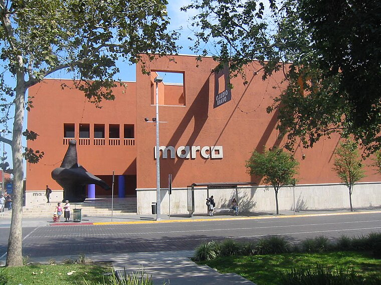 Museo de Arte Contemporáneo de Monterrey, abbreviated as MARCO, is a major contemporary art museum, located in the city of Monterrey, in Nuevo León state of northeastern Mexico. Museo de Arte Contemporáneo de Monterrey is situated 2 km north of Jesucristo de los Santos de los Ultimos Dias.
Mexican History Museum, Monterrey
Museum

Photo: Wikimedia, CC BY-SA 2.5.
Mexican History Museum, Monterrey is situated 2½ km north of Jesucristo de los Santos de los Ultimos Dias.
Pabellón M
Retail building

Photo: Mty14, CC BY-SA 4.0.
Pabellón M also known as the InverCap Tower is a mixed-use skyscraper in Monterrey, Mexico. Built between 2010 and 2015, the tower stands at 207.6 m tall with 47 floors and is the current 10th tallest building in Mexico. Pabellón M is situated 2½ km northwest of Jesucristo de los Santos de los Ultimos Dias.
Places in the Area
Nearby places include Centro and Monterrey.
Centro
 Centro is the central downtown area of Monterrey. It includes popular tourist areas like the Macroplaza and Barrio Antiguo. For the purposes of this district article, it is bounded by Ruiz Cortines on the north, Churubusco on the east, Carranza on the west, and the Santa Catarina River to the south.
Monterrey

Photo: Rick González, CC BY 2.0.
Monterrey is the third largest city in Mexico and the capital of the state of Nuevo León. It is the commercial, industrial, educational, and transportation hub of northern Mexico, also third in economic importance after Mexico City and Mexico State.
Cerro del Obispado
Locality
The Cerro del Obispado is a famous landmark in the city of Monterrey, Mexico, named after the building constructed in the middle of the slope by the end of the 18th century. Cerro del Obispado is situated 5 km northwest of Jesucristo de los Santos de los Ultimos Dias.
Jesucristo de los Santos de los Ultimos Dias
- Type: Church
- Categories: place of worship and religion
- Location: Monterrey Municipality, Nuevo León, Northern Mexico, Mexico, North America
- View on OpenStreetMap
Latitude
25.64789° or 25° 38′ 52″ northLongitude
-100.30466° or 100° 18′ 17″ westOpen location code
75QXJMXW+54OpenStreetMap ID
way 689161650OpenStreetMap feature
amenity=place_of_worship
This page is based on OpenStreetMap, Wikidata, and Wikimedia Commons.
We’d love your help improving our open data sources. Thank you for contributing.
Satellite Map
Discover Jesucristo de los Santos de los Ultimos Dias from above in high-definition satellite imagery.
Places with the Same Name
Discover other places named “Jesucristo de los Santos de los Ultimos Dias”.
Notable Places Nearby
Highlights include Roma and Parque Roma 2do Sector.
Nearby Places
Explore places such as Jesucristo de los Ultimos Dias and Residencial.
Nuevo León: Must-Visit Destinations
Delve into Monterrey, Centro, Eastern suburbs, and Western suburbs.
Curious Churches to Discover
Uncover intriguing churches from every corner of the globe.
About Mapcarta. Data © OpenStreetMap contributors and available under the Open Database License". Text is available under the CC BY-SA 4.0 license, except for photos, directions, and the map. Photo: Verzerk, CC BY-SA 3.0.