Howe Dell School
Howe Dell School is a social service facility in Hatfield, Hertfordshire, England which is located on Old Rectory Drive. Howe Dell School is situated nearby to the community center 2203 (Hatfield & de Havilland) Squadron ATC, as well as near Onslow St Audrey’s School.| Tap on a place to explore it |
- Type: Social service facility
- Description: building in Hatfield, Welwyn Hatfield, Hertfordshire, England, UK
- Also known as: “Howe Dell Manor”
- Address: Old Rectory Drive, Hatfield, AL10 8AE
Places of Interest Nearby
Highlights include Onslow St Audrey’s School and Hatfield House.
Onslow St Audrey’s School
School
Onslow St Audrey's School is a co-educational secondary school and Sixth form situated in Hatfield, Hertfordshire in England. It caters for pupils aged 11 to 18. Onslow St Audrey’s School is situated 450 feet east of Howe Dell School.
Hatfield House
Manor estate
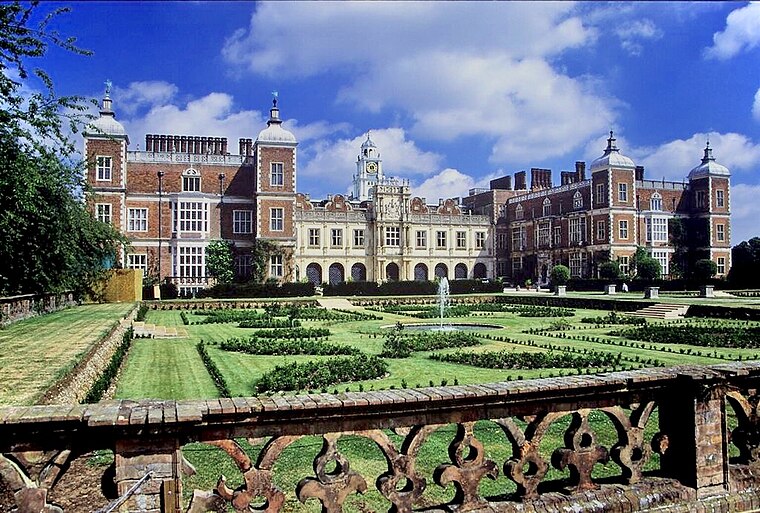
Photo: Allan Engelhardt, CC BY-SA 2.0.
Hatfield House is a Grade I listed country house set in a large park, the Great Park, on the eastern side of Hatfield, Hertfordshire, England. The present Jacobean house, a leading example of the prodigy house, was built in 1611 by Robert Cecil, 1st Earl of Salisbury and Chief Minister to King James I. Hatfield House is situated 3,300 feet east of Howe Dell School.
St. Philip Howard Catholic Primary School
School
Hatfield is a town and civil parish in Hertfordshire, England, in the borough of Welwyn Hatfield. It had a population of 29,616 in 2001, 39,201 at the 2011 census, and 41,265 at the 2021 census. St. Philip Howard Catholic Primary School is situated 770 feet southwest of Howe Dell School.
Places in the Area
Nearby places include Old Hatfield and Welham Green.
Old Hatfield
Suburb
Photo: Cmglee, CC BY-SA 3.0.
Old Hatfield, sometimes called Bishops Hatfield, is a historic village in Hertfordshire, England. It is in the town of Hatfield. It grew up on the Great North Road, one day's journey from London by horse or coach and once had many coaching inns.
Welham Green
Village

Photo: Nigel Cox, CC BY-SA 2.0.
Welham Green is a village in the parish of North Mymms, Hertfordshire, England. It is situated a mile to the west of the Great North Road coaching route that used to run through the neighbouring hamlet of Bell Bar from London to York and the north. Welham Green is situated 1½ miles south of Howe Dell School.
Sleapshyde
Hamlet
Sleapshyde is a small village in Hertfordshire, United Kingdom. It is located between Hatfield and St Albans, to the south of Smallford and to the north of Colney Heath, of which it is located in the civil parish of. Sleapshyde is situated 1½ miles southwest of Howe Dell School.
Howe Dell School
- Category: building
- Location: Hatfield, Welwyn Hatfield, Hertfordshire, East of England, England, United Kingdom, Britain and Ireland, Europe
- View on OpenStreetMap
Latitude
51.75892° or 51° 45′ 32″ northLongitude
-0.22361° or 0° 13′ 25″ westLevels
3Operator
NouvitaOpen location code
9C3XQQ5G+HHOpenStreetMap ID
way 694577110OpenStreetMap feature
amenity=social_facilityOpenStreetMap feature
building=yesWikidata ID
Q26393936
This page is based on OpenStreetMap, Wikidata, and Wikimedia Commons.
We’d love your help improving our open data sources. Thank you for contributing.
Satellite Map
Discover Howe Dell School from above in high-definition satellite imagery.
Notable Places Nearby
Highlights include 2203 (Hatfield & de Havilland) Squadron ATC and Breaks Manor Youth Centre.
Nearby Places
Explore places such as Southfield School and St Philip Howard School.
Hertfordshire: Must-Visit Destinations
Delve into St Albans, Watford, Stevenage, and Hertford.
Curious Social Service Facilities to Discover
Uncover intriguing social service facilities from every corner of the globe.
About Mapcarta. Data © OpenStreetMap contributors and available under the Open Database License". Text is available under the CC BY-SA 4.0 license, except for photos, directions, and the map. Photo: RobThinks, CC BY-SA 4.0.