Wasserhochbehälter Schlossberg
Wasserhochbehälter Schlossberg is a building in Obermoschel, Donnersbergkreis, Rhineland-Palatinate. Wasserhochbehälter Schlossberg is situated nearby to Landsberg Castle, as well as near the peak Moschel mountain.| Tap on a place to explore it |
Places of Interest Nearby
Highlights include Landsberg Castle and Moschel mountain.
Landsberg Castle
Castle

Photo: Ulli1105, CC BY-SA 3.0.
Landsberg Castle is a ruined hillside castle on the hill of Moschellandsberg near the town of Obermoschel in the German state of Rhineland-Palatinate. It may be hired out for private events. Landsberg Castle is situated 260 metres east of Wasserhochbehälter Schlossberg.

Palatine Stonemason Museum
Museum
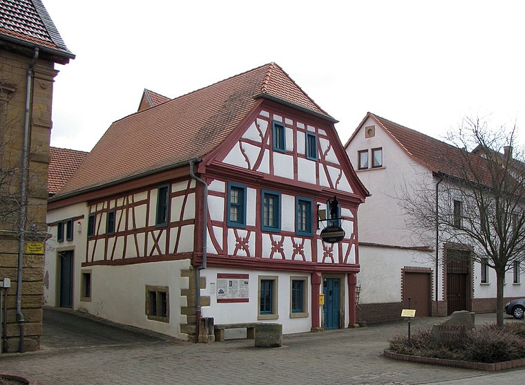
Photo: Traveler100, CC BY-SA 3.0.
The Palatine Stonemason Museum is located in a listed, historical, timber-framed house on the market place of the village of Alsenz in the German state of Rhineland-Palatinate. Palatine Stonemason Museum is situated 2½ km east of Wasserhochbehälter Schlossberg.
Places in the Area
Nearby places include Niedermoschel and Sitters.
Niedermoschel
Village
 Niedermoschel is a municipality in the Donnersbergkreis district, in Rhineland-Palatinate, Germany.
Sitters
Village

Photo: Indigotto, CC BY-SA 4.0.
Sitters is a municipality in the Donnersbergkreis district, in Rhineland-Palatinate, Germany.
Unkenbach
Village

Photo: Mosbach&frey, CC BY-SA 3.0.
Unkenbach is a municipality in the Donnersbergkreis district, in Rhineland-Palatinate, Germany. Unkenbach is situated 2½ km west of Wasserhochbehälter Schlossberg.
Wasserhochbehälter Schlossberg
- Type: Building
- Category: waterworks
- Location: Obermoschel, Donnersbergkreis, Rhineland-Palatinate, Germany, Central Europe, Europe
- View on OpenStreetMap
Latitude
49.72527° or 49° 43′ 31″ northLongitude
7.77704° or 7° 46′ 37″ eastOpen location code
8FX9PQGG+4ROpenStreetMap ID
way 744480949OpenStreetMap feature
building=serviceOpenStreetMap feature
man_made=water_works
This page is based on OpenStreetMap, Wikidata, and Wikimedia Commons.
We’d love your help improving our open data sources. Thank you for contributing.
Satellite Map
Discover Wasserhochbehälter Schlossberg from above in high-definition satellite imagery.
Notable Places Nearby
Highlights include Freiwillige Feuerwehr Obermoschel and Keiper-Platz.
Nearby Places
Explore places such as Hoher Fels and Segen Gottes.
Rhineland-Palatinate: Must-Visit Destinations
Delve into Mainz, Trier, Koblenz, and Worms.
Curious Buildings to Discover
Uncover intriguing buildings from every corner of the globe.
About Mapcarta. Data © OpenStreetMap contributors and available under the Open Database License". Text is available under the CC BY-SA 4.0 license, except for photos, directions, and the map. Photo: Traveler100, CC BY-SA 3.0.