Pier 35 1/2
Pier 35 1/2 is a pier in Philadelphia, Philadelphia Region, Pennsylvania. Pier 35 1/2 is situated nearby to the health club Riva Health & Wellness, as well as near the bus station Philadelphia Greyhound/Peter Pan Ticketing & Waiting.| Tap on a place to explore it |
Places of Interest Nearby
Highlights include Independence Hall and Liberty Bell.
Independence Hall
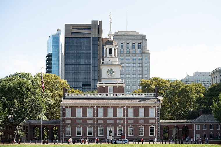
Photo: Mys 721tx, CC BY-SA 3.0.
Independence Hall is a historic civic building in Philadelphia, Pennsylvania, where both the Declaration of Independence and the Constitution of the United States were debated and adopted by the Founding Fathers of the United States. Independence Hall is situated 1¼ miles southwest of Pier 35 1/2.
Liberty Bell

Photo: tonythemisfit, CC BY 2.0.
The Liberty Bell, previously called the State House Bell or Old State House Bell, is an iconic symbol of American independence located in Philadelphia. Liberty Bell is situated 1 mile southwest of Pier 35 1/2.
Rivers Casino Philadelphia
Casino

Photo: Ii2nmd, CC BY-SA 4.0.
Rivers Casino Philadelphia, formerly SugarHouse Casino, is a casino entertainment development along the Delaware River in Philadelphia, Pennsylvania's Fishtown neighborhood, one of five stand-alone casinos awarded a gaming license on December 20, 2006 by the Pennsylvania Gaming Control Board. Rivers Casino Philadelphia is situated 1,400 feet northeast of Pier 35 1/2.
Places in the Area
Nearby places include Northern Liberties and Olde Kensington.
Northern Liberties
Neighborhood

Photo: Smallbones, Public domain.
Northern Liberties is a neighborhood in Philadelphia, Pennsylvania, United States. It is north of Center City along the Delaware River. Prior to its incorporation into Philadelphia in 1854, it was among the top 10 largest cities in the U.S. in every census from 1790 to 1840, and 11th in 1850.
Olde Kensington
Neighborhood
Olde Kensington, also known as South Kensington, is a neighborhood located in North Philadelphia section of Philadelphia, Pennsylvania, United States. South Kensington is north of Northern Liberties, south of Norris Square, east of Ludlow, and west of Fishtown.
Cooper Point
Neighborhood
Photo: Wikimedia, Public domain.
Cooper Point is a neighborhood in the northwestern part of Camden, New Jersey, United States. According to the 2000 U.S. Census, the neighborhood has a population of 2,880.
Pier 35 1/2
- Type: Pier
- Category: transportation
- Location: Philadelphia, Philadelphia, Philadelphia Region, Pennsylvania, Mid-Atlantic, United States, North America
- View on OpenStreetMap
Latitude
39.961° or 39° 57′ 40″ northLongitude
-75.13557° or 75° 8′ 8″ westOpen location code
87F6XV67+CQOpenStreetMap ID
way 749340832OpenStreetMap feature
man_made=pier
This page is based on OpenStreetMap, Wikidata, and Wikimedia Commons.
We’d love your help improving our open data sources. Thank you for contributing.
Satellite Map
Discover Pier 35 1/2 from above in high-definition satellite imagery.
Notable Places Nearby
Highlights include Riva Health & Wellness and Philadelphia Greyhound/Peter Pan Ticketing & Waiting.
Nearby Places
Explore places such as Del. River Trail & Penn St. and Waterfront Square.
Philadelphia: Must-Visit Destinations
Delve into Philadelphia International Airport, Old City, West Philadelphia, and Center City West.
Curious Piers to Discover
Uncover intriguing piers from every corner of the globe.
About Mapcarta. Data © OpenStreetMap contributors and available under the Open Database License". Text is available under the CC BY-SA 4.0 license, except for photos, directions, and the map. Photo: Dave Z, CC BY 2.0.