PAMANDZI6
PAMANDZI6 is a building in Pamandzi, Mayotte. PAMANDZI6 is situated nearby to the cemetery Cimetière de Zena Mdréré, as well as near the park Place des Congrès.| Tap on a place to explore it |
Places of Interest Nearby
Highlights include Dzaoudzi Pamandzi International Airport and Dziani Dzaha.
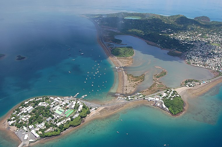
Dzaoudzi Pamandzi International Airport
Aerodrome

Photo: mwanasimba, CC BY-SA 2.0.
Dzaoudzi–Pamandzi International Airport is an airport located in Pamandzi, Mayotte, France on the southern tip of the island of Petite-Terre, east of Grande-Terre, the main island of Mayotte.
Dziani Dzaha
Lake
 Dziani Dzaha, or Lake Dziani, is a crater lake on the island of Petite Terre in the French overseas territory of Mayotte. It is known for its underwater lava tube caves and their fabled hidden pirate treasure. Dziani Dzaha is situated 3½ km north of PAMANDZI6.
Musée de Mayotte
Museum

Photo: Jean-Pierre Dalbéra, CC BY 2.0.
Musée de Mayotte is a museum, which is situated 3 km northwest of PAMANDZI6.
Places in the Area
Nearby places include Pamandzi and Labattoir.
Pamandzi
Town
 Pamandzi is a commune in the French overseas department of Mayotte, in the Indian Ocean. The commune of Pamandzi is located on the small island of Petite-Terre, off the main island of Mayotte. The Dzaoudzi–Pamandzi International Airport is located in Pamandzi.
Labattoir
Village
Dzaoudzi is a commune in the French overseas department of Mayotte, in the Indian Ocean. The commune of Dzaoudzi, made up of the twin towns of Dzaoudzi and Labattoir, is located on the small island of Petite-Terre.
Dzaoudzi
Town
 Dzaoudzi is a commune in the French overseas department of Mayotte, in the Indian Ocean. The commune of Dzaoudzi, made up of the twin towns of Dzaoudzi and Labattoir, is located on the small island of Petite-Terre. Dzaoudzi is situated 3 km northwest of PAMANDZI6.
PAMANDZI6
- Type: Building
- Location: Pamandzi, Mayotte, East African Islands, Africa
- View on OpenStreetMap
Latitude
-12.79882° or 12° 47′ 56″ southLongitude
45.27782° or 45° 16′ 40″ eastLevels
1Height
2 metres (6.6 feet)Open location code
5HV7672H+F4OpenStreetMap ID
way 754906451OpenStreetMap feature
building=yes
This page is based on OpenStreetMap, Wikidata, and Wikimedia Commons.
We’d love your help improving our open data sources. Thank you for contributing.
Satellite Map
Discover PAMANDZI6 from above in high-definition satellite imagery.
Notable Places Nearby
Highlights include Cimetière de Zena Mdréré and Grande Mosquée de Pamandzi.
Nearby Places
Explore places such as Ecole maternelle de Pamandzi 6 and Proman.
East African Islands: Must-Visit Destinations
Delve into Madagascar, Mauritius, Seychelles, and Comoros.
Curious Buildings to Discover
Uncover intriguing buildings from every corner of the globe.
About Mapcarta. Data © OpenStreetMap contributors and available under the Open Database License". Text is available under the CC BY-SA 4.0 license, except for photos, directions, and the map. Photo: MekTypro, CC BY-SA 3.0.