Kläranlage Gemeinde Oering
Kläranlage Gemeinde Oering is a wastewater treatment plant in Oering, Segeberg, Schleswig-Holstein. Kläranlage Gemeinde Oering is situated nearby to the church Apostel-Johannes-Kirche, as well as near the village Stuvenborn.| Tap on a place to explore it |
Places of Interest Nearby
Highlights include Apostel-Johannes-Kirche and Itzstedter See.
Apostel-Johannes-Kirche
Church

Photo: Tmhpr, CC BY-SA 4.0.
Apostel-Johannes-Kirche is a church, which is situated 470 metres south of Kläranlage Gemeinde Oering.
Itzstedter See
Lake

Photo: IngmarHL, CC BY-SA 3.0.
Itzstedter See is a lake, which is situated 3 km south of Kläranlage Gemeinde Oering.
Borstel Manor House
Manor estate
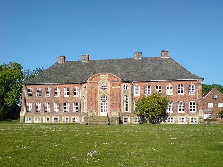
Photo: PodracerHH, CC BY-SA 3.0.
Borstel Manor House is a manor estate, which is situated 4 km southeast of Kläranlage Gemeinde Oering.
Places in the Area
Nearby places include Stuvenborn and Sievershütten.
Stuvenborn
Village
Stuvenborn is a municipality in the district of Segeberg, in Schleswig-Holstein, Germany.
Sievershütten
Village
Sievershütten is a municipality in the district of Segeberg, in Schleswig-Holstein, Germany.
Seth
Village
Seth is a municipality in the district of Segeberg, in Schleswig-Holstein, Germany. Seth is situated 2½ km northeast of Kläranlage Gemeinde Oering.
Kläranlage Gemeinde Oering
- Type: Wastewater treatment plant
- Category: industry
- Location: Oering, Segeberg, Schleswig-Holstein, Germany, Central Europe, Europe
- View on OpenStreetMap
Latitude
53.83488° or 53° 50′ 6″ northLongitude
10.14531° or 10° 8′ 43″ eastOpen location code
9F5GR4MW+X4OpenStreetMap ID
way 79130326OpenStreetMap feature
man_made=wastewater_plant
This page is based on OpenStreetMap, Wikidata, and Wikimedia Commons.
We’d love your help improving our open data sources. Thank you for contributing.
Satellite Map
Discover Kläranlage Gemeinde Oering from above in high-definition satellite imagery.
Notable Places Nearby
Highlights include Freiwillige Feuerwehr Oering and Dorfplatz.
Nearby Places
Explore places such as Brut- und Gastvögel an den Klärteichen and Wildtiere.
Schleswig-Holstein: Must-Visit Destinations
Delve into Kiel, Lübeck, Flensburg, and Heligoland.
Curious Wastewater Treatment Plants to Discover
Uncover intriguing wastewater treatment plants from every corner of the globe.
About Mapcarta. Data © OpenStreetMap contributors and available under the Open Database License". Text is available under the CC BY-SA 4.0 license, except for photos, directions, and the map. Photo: Ypsilon from Finland, CC0.