Cyberespace municipal
Cyberespace municipal is a residential building in Gentilly, Arrondissement of L’Haÿ-les-Roses, Île-de-France. Cyberespace municipal is situated nearby to the bus stop Division Leclerc - Médiathèque, as well as near the library Médiathèque Municipale.| Tap on a place to explore it |
Places of Interest Nearby
Highlights include Maison de la photographie Robert Doisneau and Town hall of Gentilly.
Maison de la photographie Robert Doisneau
Museum

Photo: Miluth, CC BY-SA 4.0.
The Maison de la photographie Robert Doisneau is a photography gallery in the Paris suburb of Gentilly, created to commemorate the Parisian photographer Robert Doisneau and dedicated to exhibiting humanist photography.
Town hall of Gentilly
Town hall

Photo: Chabe01, CC BY-SA 4.0.
Town hall of Gentilly is situated 170 metres northeast of Cyberespace municipal.
Stade Sébastien Charléty
Stadium
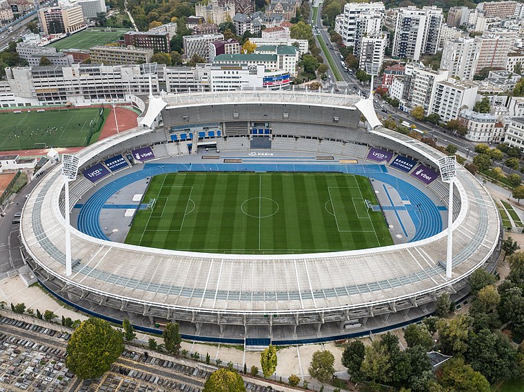
Photo: Wikimedia, CC BY-SA 3.0 de.
Stade Sébastien-Charléty, also known as Stade Charléty or Charléty, is a multi-purpose stadium located in the 13th arrondissement of Paris, France. Comprising a running track and a football field, the stadium is a 20,000-seat state-owned venue used for numerous sports and events. Stade Sébastien Charléty is situated 420 metres north of Cyberespace municipal.
Places in the Area
Nearby places include Gentilly and Porte de Gentilly.
Gentilly
Town

Photo: Ralf.treinen, CC BY-SA 3.0.
Gentilly is a commune in the southern suburbs of Paris, France. It is the closest commune to Paris, located 4.1 km from the city center.

Le Kremlin-Bicêtre
Town

Photo: Chabe01, CC BY-SA 4.0.
Le Kremlin-Bicêtre is a commune in the southern suburbs of Paris, France. It is 4.5 km from the center of Paris. It is one of the most densely populated municipalities in Europe.
Cyberespace municipal
- Type: Residential building
- Address: 15
- Category: building
- Location: Gentilly, Arrondissement of L’Haÿ-les-Roses, Val-de-Marne, Île-de-France, France, Europe
- View on OpenStreetMap
Latitude
48.81421° or 48° 48′ 51″ northLongitude
2.34641° or 2° 20′ 47″ eastLevels
2Open location code
8FW4R87W+MHOpenStreetMap ID
way 81091805OpenStreetMap feature
building=residential
This page is based on OpenStreetMap, Wikidata, and Wikimedia Commons.
We’d love your help improving our open data sources. Thank you for contributing.
Satellite Map
Discover Cyberespace municipal from above in high-definition satellite imagery.
Notable Places Nearby
Highlights include Division Leclerc - Médiathèque and Médiathèque Municipale.
Nearby Places
Explore places such as La Sauge and Passage des lavandières de la Bièvre.
Île-de-France: Must-Visit Destinations
Delve into Paris, Versailles, Boulogne-Billancourt, and Paris Charles de Gaulle Airport.
Curious Residential Buildings to Discover
Uncover intriguing residential buildings from every corner of the globe.
About Mapcarta. Data © OpenStreetMap contributors and available under the Open Database License". Text is available under the CC BY-SA 4.0 license, except for photos, directions, and the map. Photo: Guillaume Baviere, CC BY 2.0.