The Kensington
The Kensington is in South Kensington-Chelsea, Greater London, England. The Kensington is situated nearby to the building Odeon Kensington, as well as near St Barnabas and St Philip’s CofE Primary School.| Tap on a place to explore it |
Places of Interest Nearby
Highlights include Design Museum and Leighton House Museum.
Design Museum
Museum
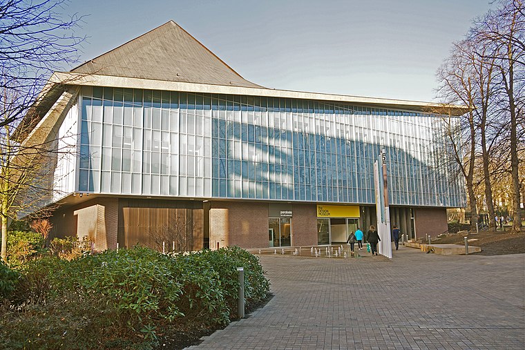
Photo: Anthony O’Neil, CC BY-SA 2.0.
The Design Museum in Kensington, London, England, exhibits product, industrial, graphic, fashion, and architectural design. In 2018, the museum won the European Museum of the Year Award. Design Museum is situated 600 feet northwest of The Kensington.
Leighton House Museum
Museum

Photo: Wikimedia, CC BY-SA 4.0.
The Leighton House Museum is an art museum and historic house in the Holland Park area of the Royal Borough of Kensington and Chelsea in west London. The building was the London home of painter Frederic Leighton, 1st Baron Leighton, who commissioned the… Leighton House Museum is situated 950 feet west of The Kensington.
Our Lady of Victories
Church

Photo: Edwardx, CC BY-SA 4.0.
Our Lady of Victories, in Kensington, London, is a Roman Catholic church. The original church opened in 1869, and for 34 years to 1903 served as pro-cathedral of the Archdiocese of Westminster. Our Lady of Victories is situated 360 feet east of The Kensington.
Places in the Area
Nearby places include Kensington and Earls Court.
Kensington
Suburb

Photo: Yaanch, Public domain.
Kensington is an area of London in the Royal Borough of Kensington and Chelsea, around 2.9 miles west of Central London. The district's commercial heart is Kensington High Street, running on an east–west axis.
Earls Court
Suburb

Photo: Wikimedia, Public domain.
Earl's Court is a district of Kensington in the Royal Borough of Kensington and Chelsea in West London, bordering the rail tracks of the West London line and District line that separate it from the ancient borough of Fulham to the west, the sub-districts of South Kensington to the east, Chelsea to the south and Kensington to the northeast.
West Kensington
Suburb

Photo: David Hawgood, CC BY-SA 2.0.
West Kensington, formerly North End, is an area in the ancient parish of Fulham, in the London Borough of Hammersmith and Fulham, England, 3.4 miles west of Charing Cross.
The Kensington
Latitude
51.49844° or 51° 29′ 54″ northLongitude
-0.1989° or 0° 11′ 56″ westOpen location code
9C3XFRX2+9COpenStreetMap ID
way 828220875OpenStreetMap feature
landuse=construction
This page is based on OpenStreetMap, Wikidata, and Wikimedia Commons.
We’d love your help improving our open data sources. Thank you for contributing.
Satellite Map
Discover The Kensington from above in high-definition satellite imagery.
Places with the Same Name
Discover other places named “The Kensington”.
Notable Places Nearby
Highlights include Odeon Kensington and St Barnabas and St Philip’s CofE Primary School.
Nearby Places
Explore places such as Cafe de Fred and Kensington Nails.
London: Must-Visit Destinations
Delve into Heathrow Airport, City of London, Westminster, and South London.
Curious Places to Discover
Uncover intriguing places from every corner of the globe.
About Mapcarta. Data © OpenStreetMap contributors and available under the Open Database License". Text is available under the CC BY-SA 4.0 license, except for photos, directions, and the map. Photo: Peter Suranyi, CC BY-SA 3.0.