Locoreria
Locoreria is a retail building in Monterrey Municipality, Nuevo León which is located on Avenida Río Pánuco. Locoreria is situated nearby to the park Parque Tecnológico, as well as near Parque Roma.| Tap on a place to explore it |
Places of Interest Nearby
Highlights include Museo de Arte Contemporáneo de Monterrey and Mexican History Museum, Monterrey.
Museo de Arte Contemporáneo de Monterrey
Museum
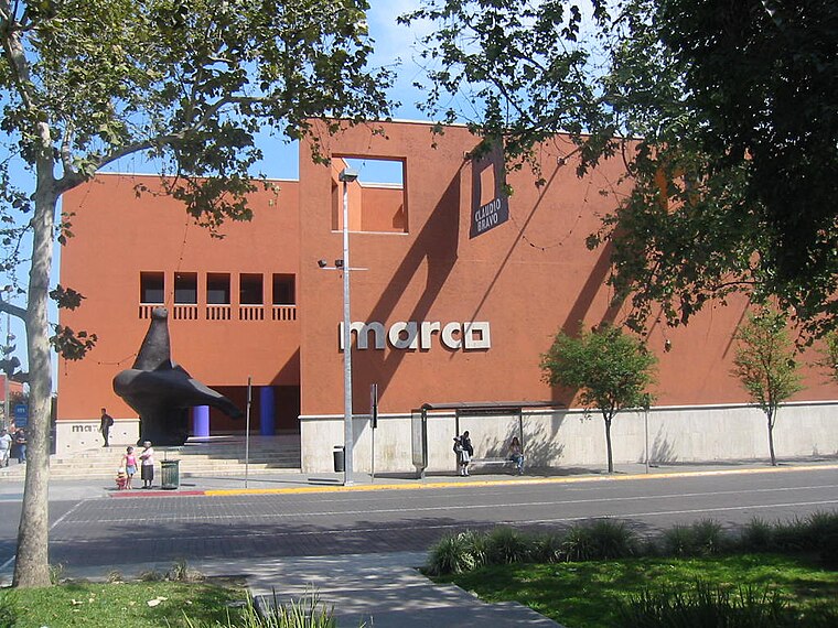 Museo de Arte Contemporáneo de Monterrey, abbreviated as MARCO, is a major contemporary art museum, located in the city of Monterrey, in Nuevo León state of northeastern Mexico. Museo de Arte Contemporáneo de Monterrey is situated 2 km northwest of Locoreria.
Mexican History Museum, Monterrey
Museum

Photo: Wikimedia, CC BY-SA 2.5.
Mexican History Museum, Monterrey is situated 2½ km north of Locoreria.
La Purísima
Church

Photo: Wikimedia, CC BY-SA 2.0.
La Purísima is a church, which is situated 3½ km northwest of Locoreria.
Places in the Area
Nearby places include Centro and Monterrey.
Centro
 Centro is the central downtown area of Monterrey. It includes popular tourist areas like the Macroplaza and Barrio Antiguo. For the purposes of this district article, it is bounded by Ruiz Cortines on the north, Churubusco on the east, Carranza on the west, and the Santa Catarina River to the south.
Monterrey

Photo: Rick González, CC BY 2.0.
Monterrey is the third largest city in Mexico and the capital of the state of Nuevo León. It is the commercial, industrial, educational, and transportation hub of northern Mexico, also third in economic importance after Mexico City and Mexico State.
Outer Monterrey
 Outer Monterrey refers to the parts of the city of Monterrey beyond the Centro district. This is a very large area and includes areas north and west of el Centro and areas to the south and east of el Centro.
Locoreria
- Type: Retail building
- Address: Avenida Río Pánuco, Monterrey
- Category: building
- Location: Monterrey Municipality, Nuevo León, Northern Mexico, Mexico, North America
- View on OpenStreetMap
Latitude
25.64907° or 25° 38′ 57″ northLongitude
-100.29698° or 100° 17′ 49″ westLevels
1Open location code
75QXJPX3+J6OpenStreetMap ID
way 867060667OpenStreetMap feature
building=retail
This page is based on OpenStreetMap, Wikidata, and Wikimedia Commons.
We’d love your help improving our open data sources. Thank you for contributing.
Satellite Map
Discover Locoreria from above in high-definition satellite imagery.
Notable Places Nearby
Highlights include Parque Tecnológico and Parque Roma.
Nearby Places
Explore places such as Oxxo and DentaTec.
Nuevo León: Must-Visit Destinations
Delve into Monterrey, Centro, Eastern suburbs, and Western suburbs.
Curious Retail Buildings to Discover
Uncover intriguing retail buildings from every corner of the globe.
About Mapcarta. Data © OpenStreetMap contributors and available under the Open Database License". Text is available under the CC BY-SA 4.0 license, except for photos, directions, and the map. Photo: Verzerk, CC BY-SA 3.0.