ESCUELA YAMANDÚ
ESCUELA YAMANDÚ is a school building in Asunción, Southern Paraneña. ESCUELA YAMANDÚ is situated nearby to the church Misión de Amistad, as well as near the neighborhood Pinozá.| Tap on a place to explore it |
Places of Interest Nearby
Highlights include Estadio Rogelio Livieres and Estadio Osvaldo Domínguez Dibb.
Estadio Rogelio Livieres
Pitch
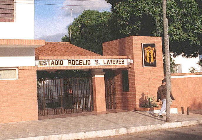
Photo: Edgar Andino, Public domain.
Estadio Rogelio Livieres is a multi-use stadium in Asunción, Paraguay. It is currently used mostly for football matches and is the home stadium of Club Guaraní. The stadium holds 8,000 people. Estadio Rogelio Livieres is situated 230 metres northwest of ESCUELA YAMANDÚ.
Estadio Osvaldo Domínguez Dibb
Stadium

Photo: Wikimedia, CC BY-SA 4.0.
The Estadio Osvaldo Domínguez Dibb, known until March 2024 as Estadio Manuel Ferreira, and officially Estadio ueno Osvaldo Domínguez Dibb due to sponsorship by banking company Ueno, is a football stadium in Asunción, Paraguay. Estadio Osvaldo Domínguez Dibb is situated 1½ km northeast of ESCUELA YAMANDÚ.
Apostolic Nunciature
Government office
The Apostolic Nunciature to Paraguay is an ecclesiastical office of the Catholic Church in Paraguay. It is a diplomatic post of the Holy See, whose representative is called the Apostolic Nuncio with the rank of an ambassador. Apostolic Nunciature is situated 1¼ km northeast of ESCUELA YAMANDÚ.
Places in the Area
Nearby places include Pinozá and General Caballero.
ESCUELA YAMANDÚ
- Type: School building
- Categories: building and education
- Location: Asunción, Southern Paraneña, Paraguay, South America
- View on OpenStreetMap
Latitude
-25.30538° or 25° 18′ 19″ southLongitude
-57.61502° or 57° 36′ 54″ westOpen location code
5864M9VM+RXOpenStreetMap ID
way 923218989OpenStreetMap feature
building=school
This page is based on OpenStreetMap, Wikidata, and Wikimedia Commons.
We’d love your help improving our open data sources. Thank you for contributing.
Satellite Map
Discover ESCUELA YAMANDÚ from above in high-definition satellite imagery.
Notable Places Nearby
Highlights include Misión de Amistad and Misión de Amistad.
Nearby Places
Explore places such as Todo Market and Super Pizza.
Southern Paraneña: Must-Visit Destinations
Delve into Pilar, Areguá, Villeta, and Ypacarai.
Curious Schools to Discover
Uncover intriguing schools from every corner of the globe.
About Mapcarta. Data © OpenStreetMap contributors and available under the Open Database License". Text is available under the CC BY-SA 4.0 license, except for photos, directions, and the map. Photo: FF MM, CC BY-SA 3.0.