Canterbury Business Centre
Canterbury Business Centre is in Tewkesbury, Gloucestershire, England. Canterbury Business Centre is situated nearby to the community center The Boys‘ Brigade Community Centre, as well as near the health club Target Active Fitness.| Tap on a place to explore it |
Places of Interest Nearby
Highlights include Tewkesbury Abbey and Tewkesbury Museum.
Tewkesbury Abbey
Church

Photo: Saffron Blaze, CC BY-SA 3.0.
The Parish Church of St Mary the Virgin, Tewkesbury, commonly known as Tewkesbury Abbey, is located in the town of Tewkesbury in the ceremonial county of Gloucestershire, England. Tewkesbury Abbey is situated 1 mile southwest of Canterbury Business Centre.
Tewkesbury Museum
Museum

Photo: Neil Owen, CC BY-SA 2.0.
Tewkesbury Museum is a small community museum dedicated to the social history and heritage of Tewkesbury in Gloucestershire, England. The museum is housed in a 17th-century half-timbered building at 64 and 64a Barton Street, in property which was given to the Borough of Tewkesbury in 1956 on the express condition that it be used as a museum. Tewkesbury Museum is situated 3,700 feet west of Canterbury Business Centre.
Tewkesbury School
School
Tewkesbury Academy is a secondary school in the English town of Tewkesbury in Gloucestershire. It has been an academy since 2012; in July 2023 its name was changed to reflect this. Since 2022 the head teacher has been Kathleen McGillycuddy. Tewkesbury School is situated 2,400 feet east of Canterbury Business Centre.
Places in the Area
Nearby places include Walton Cardiff and Ashchurch.
Walton Cardiff
Hamlet

Photo: Philip Halling, CC BY-SA 2.0.
Walton Cardiff is a village and former civil parish, now in the parish of Ashchurch Rural, in the Borough of Tewkesbury, in Gloucestershire, England. In 2001, the parish had a population of 1291.
Ashchurch
Suburb
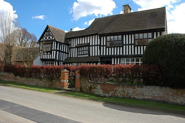
Photo: Philip Halling, CC BY-SA 2.0.
Ashchurch is a village and former civil parish, now in the parish of Ashchurch Rural, in the Tewkesbury district, in the county of Gloucestershire, England, 2 miles east of the town of Tewkesbury, 11 mi southwest of Evesham, 10 mi north of Cheltenham, 13 mi north-north-east of Gloucester and 10 mi south of Pershore.
Bushley
Village

Photo: Philip Halling, CC BY-SA 2.0.
Bushley is a small village and civil parish in the Malvern Hills district in Worcestershire, England. The church is dedicated to Saint Peter. At the 2021 census, the population was 372. Bredon School is located to the north of the village. Bushley is situated 2 miles west of Canterbury Business Centre.
Canterbury Business Centre
- Type: Commerce
- Location: Tewkesbury, Tewkesbury, Gloucestershire, West Country, England, United Kingdom, Britain and Ireland, Europe
- View on OpenStreetMap
Latitude
51.99619° or 51° 59′ 46″ northLongitude
-2.13978° or 2° 8′ 23″ westOpen location code
9C3VXVW6+F3OpenStreetMap ID
way 959172917OpenStreetMap feature
landuse=commercial
This page is based on OpenStreetMap, Wikidata, and Wikimedia Commons.
We’d love your help improving our open data sources. Thank you for contributing.
Satellite Map
Discover Canterbury Business Centre from above in high-definition satellite imagery.
Notable Places Nearby
Highlights include The Boys‘ Brigade Community Centre and Target Active Fitness.
Nearby Places
Explore places such as The Canterbury and Charlton Networks.
Gloucestershire: Must-Visit Destinations
Delve into Gloucester, Cheltenham, Cirencester, and Yate.
Curious Places to Discover
Uncover intriguing places from every corner of the globe.
About Mapcarta. Data © OpenStreetMap contributors and available under the Open Database License". Text is available under the CC BY-SA 4.0 license, except for photos, directions, and the map. Photo: Wikimedia, CC BY 2.5.