Bradley Lane Substation
Bradley Lane Substation is an electrical substation in Newton Abbot, Teignbridge District, England. Bradley Lane Substation is situated nearby to the sports venue Steve’s Gym, as well as near River Lemon.| Tap on a place to explore it |
Places of Interest Nearby
Highlights include Alexandra Theatre and Passmore Edwards Centre.
Alexandra Theatre
Movie theater
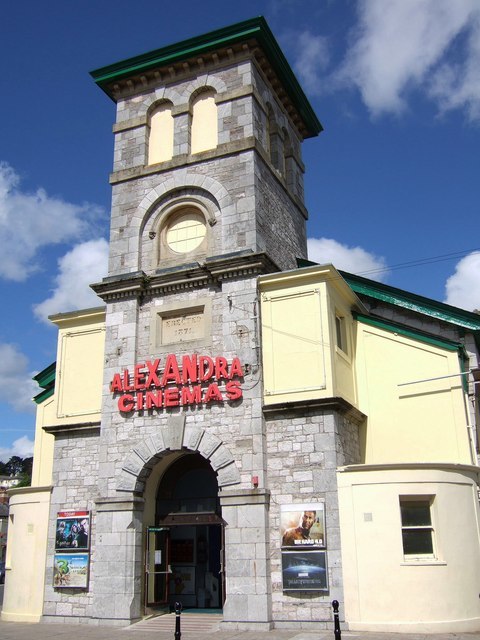
Photo: Derek Harper, CC BY-SA 2.0.
The Alexandra Theatre is an entertainment complex in Market Street, Newton Abbot, Devon, England. The structure, which was commissioned as a corn exchange and is currently used as a cinema, is a Grade II listed building. Alexandra Theatre is situated 1,600 feet northeast of Bradley Lane Substation.
Passmore Edwards Centre
Library

Photo: Smalljim, CC BY-SA 3.0.
The Passmore Edwards Centre is a grade II listed building in Newton Abbot, Devon, in England. It was built as a library and technical school by philanthropist John Passmore Edwards in memory of his mother who was born in the town. Passmore Edwards Centre is situated 1,300 feet east of Bradley Lane Substation.
Bradley

Photo: Smalljim, CC BY-SA 3.0.
Bradley is a medieval manor house in Newton Abbot, Devon, England. It is set amongst woodland and meadows in the valley of the River Lemon about a half mile to the west of the main town. The house is now in the ownership of the National Trust. Bradley is situated 2,100 feet southwest of Bradley Lane Substation.
Places in the Area
Nearby places include Milber and Kingsteignton.
Milber
Suburb

Photo: Paul Hutchinson, CC BY-SA 2.0.
Milber is a suburban area of Newton Abbot and former civil parish, now in the parish of Newton Abbot, in the Teignbridge district of Devon, England. Much of the area comprises a housing estate at grid reference SX8770.
Kingsteignton
Town

Photo: Richard Knights, CC BY-SA 2.0.
Kingsteignton, is a town and civil parish in south Devon, England. It lies at the head of the Teign Estuary to the west of Teignmouth in the Teignbridge district. Kingsteignton is situated 1½ miles northeast of Bradley Lane Substation.
Milber Down
Locality

Photo: Derek Harper, CC BY-SA 2.0.
Milber Down is an Iron Age hill fort on the hill above the suburb of Milber, Newton Abbot in Devon, England. The fort is situated on the north-western slope of Milber Down at about 110 metres above sea level, and is bisected by the minor ridge road that leads to Barton, Torquay. Milber Down is situated 2 miles southeast of Bradley Lane Substation.
Bradley Lane Substation
- Type: Electrical substation
- Category: industry
- Location: Newton Abbot, Teignbridge District, English Riviera and South Devon, Devon, West Country, England, United Kingdom, Britain and Ireland, Europe
- View on OpenStreetMap
Latitude
50.52912° or 50° 31′ 45″ northLongitude
-3.61824° or 3° 37′ 6″ westOpen location code
9C2RG9HJ+JPOpenStreetMap ID
way 974759942
This page is based on OpenStreetMap, Wikidata, and Wikimedia Commons.
We’d love your help improving our open data sources. Thank you for contributing.
Satellite Map
Discover Bradley Lane Substation from above in high-definition satellite imagery.
Notable Places Nearby
Highlights include Steve’s Gym and River Lemon.
Nearby Places
Explore places such as Bradley Lane Car Park and CR Motors.
English Riviera and South Devon: Must-Visit Destinations
Delve into Torquay, Dartmouth, Paignton, and Teignmouth.
Curious Electrical Substations to Discover
Uncover intriguing electrical substations from every corner of the globe.
About Mapcarta. Data © OpenStreetMap contributors and available under the Open Database License". Text is available under the CC BY-SA 4.0 license, except for photos, directions, and the map. Photo: Lobsterthermidor, Public domain.