Le Vert de Maisons
Le Vert de Maisons is a railway station in Alfortville, Arrondissement of Créteil, Île-de-France. Le Vert de Maisons is situated nearby to the bike rental Liberté - Vert-de-Maisons, as well as near the park Parc du Vert-de-Maisons.| Tap on a place to explore it |
Places of Interest Nearby
Highlights include Le Vert de Maisons station and Liberté - Vert-de-Maisons.
Le Vert de Maisons station
Railway station

Photo: Wikimedia, CC BY-SA 3.0.
Le Vert de Maisons is a railway station in Maisons-Alfort and Alfortville, Val-de-Marne, Île-de-France, France. The station was opened on 28 May 1955 and is on the Paris–Marseille railway.
Liberté - Vert-de-Maisons
Bike rental

Photo: Chabe01, CC BY-SA 4.0.
Liberté - Vert-de-Maisons is a bike rental.
Église des Frères Évangéliques Arméniens d’Alfortville
Church

Photo: Chabe01, CC BY-SA 4.0.
Église des Frères Évangéliques Arméniens d’Alfortville is a church, which is situated 240 metres southwest of Le Vert de Maisons.
Places in the Area
Nearby places include Maisons-Alfort and Alfortville.
Maisons-Alfort
Town
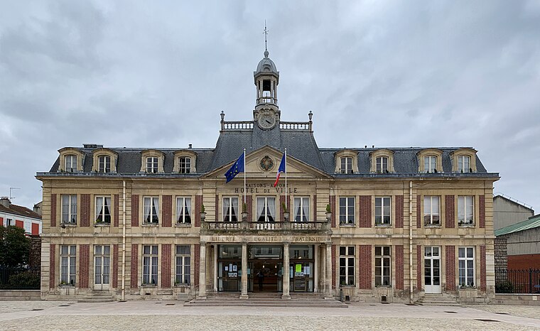
Photo: Chabe01, CC BY-SA 4.0.
Maisons-Alfort is a commune in the southeastern suburbs of Paris, France. It is located 8.4 km from the center of Paris. Maisons-Alfort is famous as the location of the National Veterinary School of Alfort.
Alfortville
Town
Photo: Pline, CC BY-SA 3.0.
Alfortville is a commune in the Val-de-Marne department in the southeastern suburbs of Paris, France. It is located 7.6 km from the center of Paris. It is one of the 13 communes in the intercommunality of Métropole du Grand Paris.
Créteil
Town

Photo: Paul Fleury, CC BY 3.0.
Créteil is a commune in the southeastern suburbs of Paris, Île-de-France. It is located 11.7 km from the centre of Paris. Créteil is the préfecture of the Val-de-Marne department as well as the seat of the Arrondissement of Créteil.
Le Vert de Maisons
- Type: Railway station
- Wheelchair access: yes
- Categories: building and transportation
- Location: Alfortville, Arrondissement of Créteil, Val-de-Marne, Île-de-France, France, Europe
- View on OpenStreetMap
Latitude
48.78957° or 48° 47′ 23″ northLongitude
2.43208° or 2° 25′ 56″ eastOperator
SNCFOpen location code
8FW4QCQJ+RROpenStreetMap ID
way 989874204OpenStreetMap feature
building=train_stationOpenStreetMap attribute
wheelchair=yes
This page is based on OpenStreetMap, Wikidata, and Wikimedia Commons.
We’d love your help improving our open data sources. Thank you for contributing.
Satellite Map
Discover Le Vert de Maisons from above in high-definition satellite imagery.
Places with the Same Name
Discover other places named “Le Vert de Maisons”.
Notable Places Nearby
Highlights include Parc du Vert-de-Maisons and Place de l’Europe.
Nearby Places
Explore places such as Guichet Transilien and Gare du Vert de Maison.
Île-de-France: Must-Visit Destinations
Delve into Paris, Versailles, Boulogne-Billancourt, and Paris Charles de Gaulle Airport.
Curious Railway Stations to Discover
Uncover intriguing railway stations from every corner of the globe.
About Mapcarta. Data © OpenStreetMap contributors and available under the Open Database License". Text is available under the CC BY-SA 4.0 license, except for photos, directions, and the map. Photo: Guillaume Baviere, CC BY 2.0.