The Original Curryland
The Original Curryland is a restaurant in Worthing District, West Sussex, England. The Original Curryland is situated nearby to West Worthing Railway Station, as well as near Tarring Crossing Post Office.| Tap on a place to explore it |
- Opening hours: 5:00 PM—9:00 PM
- Type: Restaurant
- Cuisine: Indian
Places of Interest Nearby
Highlights include West Worthing railway station and St Botolph’s Church, Heene.
West Worthing railway station
Railway station

Photo: Hassocks5489, Public domain.
West Worthing railway station is one of five stations serving the town of Worthing in the county of West Sussex, England. It is 11 miles 30 chains down the line from Brighton. The station is operated by Southern. West Worthing railway station is situated 390 feet west of The Original Curryland.
St Botolph’s Church, Heene
Church

Photo: The Voice of Hassocks, CC0.
St Botolph's Church is an Anglican church in the Heene area of the borough of Worthing, one of seven local government districts in the English county of West Sussex. St Botolph’s Church, Heene is situated 2,000 feet southeast of The Original Curryland.
St Matthew
Church
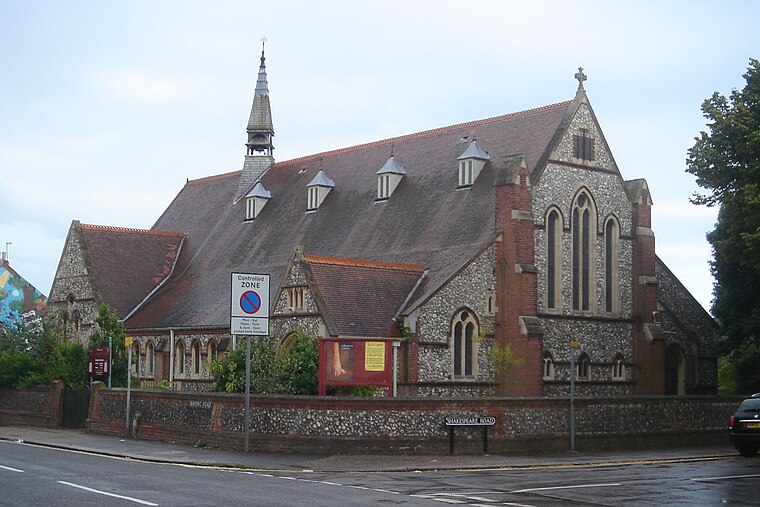
Photo: The Voice of Hassocks, Public domain.
St Matthew is a church, which is situated 2,000 feet east of The Original Curryland.
Places in the Area
Nearby places include Broadwater and Worthing.
Broadwater
Suburb

Photo: Oxenhillshaw, Public domain.
Broadwater is a neighbourhood of Worthing, in the borough of Worthing in West Sussex, England. Situated between the South Downs and the English Channel, Broadwater was once a parish in its own right and included Worthing when the latter was a small fishing hamlet.
Worthing

Photo: Mattbuck, CC BY-SA 4.0.
Worthing is the largest town in West Sussex. The town lies nestled between the English Channel and the South Downs National Park. It is a seaside town with a pier, a prom and pleasant seaside parks.
Durrington
Suburb

Photo: Peter Holmes, CC BY-SA 2.0.
Durrington is a neighbourhood of Worthing and former civil parish, now in the borough of Worthing in West Sussex, England. Historically in Sussex, in the rape of Bramber, it is situated near the A27 road, 2.3 miles northwest of the town centre.
The Original Curryland
- Categories: building and food
- Location: Worthing District, West Sussex, South East England, England, United Kingdom, Britain and Ireland, Europe
- View on OpenStreetMap
Latitude
50.8182° or 50° 49′ 6″ northLongitude
-0.39168° or 0° 23′ 30″ westOpen location code
9C2XRJ95+78OpenStreetMap ID
way 991978654OpenStreetMap feature
amenity=restaurantOpenStreetMap feature
building=yesOpenStreetMap attribute
cuisine=indian
This page is based on OpenStreetMap, Wikidata, and Wikimedia Commons.
We’d love your help improving our open data sources. Thank you for contributing.
Satellite Map
Discover The Original Curryland from above in high-definition satellite imagery.
Notable Places Nearby
Highlights include West Worthing Railway Station and Tarring Crossing Post Office.
Nearby Places
Explore places such as Marshall’s and DFC Property Management Limited.
West Sussex: Must-Visit Destinations
Delve into Chichester, Crawley, Worthing, and Horsham.
Curious Restaurants to Discover
Uncover intriguing restaurants from every corner of the globe.
About Mapcarta. Data © OpenStreetMap contributors and available under the Open Database License". Text is available under the CC BY-SA 4.0 license, except for photos, directions, and the map. Photo: wildlife encounters, CC BY 2.0.