Træet
Træet is a farm in Bergen, Hordaland, Western Norway. Træet is situated nearby to the locality Middagshaugen, as well as near Hyttelien.| Tap on a place to explore it |
Places of Interest
Highlights include Rundemanen and Fløyen.
Rundemanen
Peak

Photo: LK-Nor, CC BY-SA 3.0.
Rundemanen is a mountain in Bergen Municipality in Vestland county, Norway. It is considered one of the Seven Mountains which surround the city centre of Bergen, its elevation of 568 metres makes it the second highest of them all.
Fløyen
Peak

Photo: Njardarlogar, CC BY-SA 4.0.
Fløyen or Fløyfjellet is a mountain in Bergen Municipality in Vestland county, Norway. It is one of the "seven city mountains" that surround the centre of the city of Bergen. Fløyen is situated 3½ km south of Træet.
Bergenhus Fortress
Park
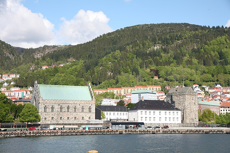
Photo: Wikimedia, CC BY-SA 2.5.
Bergenhus fortress is a fortress located in Bergen, Norway. Located at the entrance of Bergen harbour, the castle is one of the oldest and best preserved stone fortifications in Norway. Bergenhus Fortress is situated 4 km southwest of Træet.
Places in the Area
Nearby places include Sandviksfjellet and Brushytten.
Sandviksfjellet
Locality

Photo: Shark, CC BY-SA 3.0.
Sandviksfjellet is a mountain in Bergen Municipality in Vestland county, Norway. It is one of the traditional seven mountains that surround the city centre of Bergen.
Brushytten
Locality

Photo: Smtunli, CC BY-SA 4.0.
Brushytten is a locality, which is situated 3 km south of Træet.
Ytre Arna
Village

Photo: Shark, CC BY-SA 3.0.
Ytre Arna is a village area in the borough of Arna in Bergen Municipality in Vestland county, Norway. Ytre Arna is principally associated with A/S Arne Fabrikker, the country's first mechanised cotton mill. Ytre Arna Church is also located in the village. Ytre Arna is situated 5 km northeast of Træet.
Træet
- Type: Farm
- Also known as: “Traeet”
- Categories: locality and agriculture
- Location: Bergen, Hordaland, Western Norway, Norway, Nordic countries, Europe
- View on OpenStreetMap
Latitude
60.4267° or 60° 25′ 36″ northLongitude
5.36583° or 5° 21′ 57″ eastElevation
203 metres (666 feet)Open location code
9FG7C9G8+M8OpenStreetMap ID
node 5538716500OpenStreetMap feature
place=farmGeoNames ID
9502707
This page is based on OpenStreetMap, GeoNames, Wikidata, and Wikimedia Commons.
We’d love your help improving our open data sources. Thank you for contributing.
Satellite Map
Discover Træet from above in high-definition satellite imagery.
In Other Languages
“Træet” goes by many names.
- Norwegian: “Træet”
Places with the Same Name
Discover other places named “Træet”.
Localities in the Area
Explore places such as Middagshaugen and Hyttelien.
Notable Places Nearby
Highlights include Ulskebjørnen and Fureberget.
Hordaland: Must-Visit Destinations
Delve into Voss, Ullensvang, Askøy, and Eidfjord.
Curious Places to Discover
Uncover intriguing places from every corner of the globe.
About Mapcarta. Data © OpenStreetMap contributors and available under the Open Database License". Text is available under the CC BY-SA 4.0 license, except for photos, directions, and the map. Photo: Gatm, CC BY-SA 3.0.