Kungsbron
Kungsbron is a hotel in Stockholm, Stockholm Municipality, Stockholm County. Kungsbron is situated nearby to the government office Embassy of Belgium, as well as near the theater building Oscarsteatern.| Tap on a place to explore it |
Places of Interest Nearby
Highlights include Stockholm Central Station and Embassy of Belgium.
Stockholm Central Station
Railway station

Photo: Wikimedia, CC BY-SA 3.0.
Stockholm Central Station, is the main railway station in Stockholm, and largest railway station in Sweden in terms of passenger numbers and train traffic. Stockholm Central Station is situated 360 metres southeast of Kungsbron.
Embassy of Belgium
Government office

Photo: Ainali, CC BY-SA 3.0.
Embassy of Belgium is a government office, which is situated 230 metres west of Kungsbron.
Oscarsteatern
Theater building
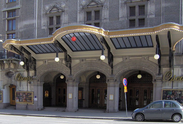
Photo: Kalle1, Public domain.
Oscarsteatern, also known simply as Oscars, is one of Stockholm's private theatres and is the best-known musical theatre in Sweden. It is located at Kungsgatan 63 in central Stockholm. Oscarsteatern is situated 230 metres northeast of Kungsbron.
Places in the Area
Nearby places include Norrmalm and Klara.
Norrmalm

Photo: Wikimedia, CC BY-SA 3.0.
Norrmalm, also known as City, is the central borough of Stockholm, bordering to Östermalm to the east at Birger Jarlsgatan, the Old Town to the south, Kungsholmen to the south-west, and Vasastan north-west of Tegnérgatan.
Klara
Neighborhood
Photo: ArildV, CC BY-SA 3.0.
Klara is a part of lower Norrmalm in the central part of Stockholm. It has its name from Klara Church. Today the name, though not often used in daily speech, has become synonymous with the old city that once occupied lower Norrmalm.
Kungsholmen

Photo: Wikimedia, CC BY-SA 3.0.
Kungsholmen is an urban island which makes up the western part of Stockholm's inner city, with the Stockholm City Hall, Stockholms stadshus, as a dominant landmark.
Kungsbron
- Type: Hotel
- Wheelchair access: yes
- Categories: tourism, accommodation, and building
- Location: Stockholm, Stockholms domkyrkoförs., Stockholm Municipality, Stockholm County, Svealand, Sweden, Nordic countries, Europe
- View on OpenStreetMap
Latitude
59.33208° or 59° 19′ 56″ northLongitude
18.05297° or 18° 3′ 11″ eastElevation
22 metres (72 feet)Open location code
9FFW83J3+R5OpenStreetMap ID
node 806864906OpenStreetMap feature
tourism=hotelOpenStreetMap attribute
wheelchair=yesGeoNames ID
10111174
This page is based on OpenStreetMap, GeoNames, Wikidata, and Wikimedia Commons.
We’d love your help improving our open data sources. Thank you for contributing.
Satellite Map
Discover Kungsbron from above in high-definition satellite imagery.
Localities in the Area
Explore places such as Sabbatsberg and Vasastan and Hagastaden.
Nearby Places
Explore places such as Agilokliniken Stockholm City and Blekholmen.
Stockholm County: Must-Visit Destinations
Delve into Stockholm, Södermalm, Södertälje, and Norrmalm.
Curious Hotels to Discover
Uncover intriguing hotels from every corner of the globe.
About Mapcarta. Data © OpenStreetMap contributors and available under the Open Database License". Text is available under the CC BY-SA 4.0 license, except for photos, directions, and the map. Photo: Smiley.toerist, CC BY-SA 4.0.