Kaikai Chicken
Kaikai Chicken is a restaurant in Brisbane, Queensland. Kaikai Chicken is situated nearby to the post office St Lucia South LPO, as well as near the health club Xtend Barre.| Tap on a place to explore it |
- Opening hours:
Tuesday—Thursday: 5:30 PM—9:30 PM
Friday and Saturday: 5:30 PM—10:00 PM
Sunday: 5:30 PM—9:30 PM - Type: Restaurant
- Cuisine: Korean
- Wheelchair access: no
Places of Interest Nearby
Highlights include The Gabba and Thomas Dixon Centre.
The Gabba
Stadium
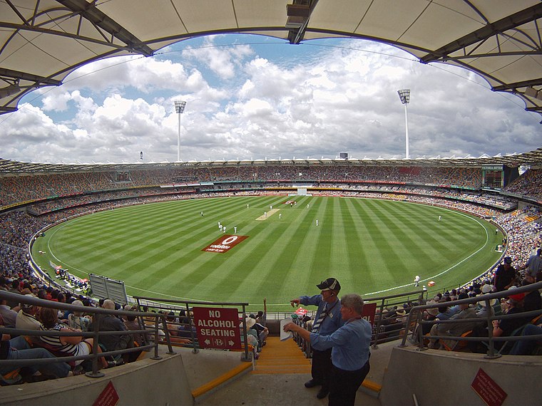 The Brisbane Cricket Ground, commonly known as the Gabba, is a major sports stadium in Brisbane, the capital of Queensland, Australia. The nickname Gabba derives from the suburb of Woolloongabba, in which it is located. The Gabba is situated 3½ km northeast of Kaikai Chicken.
Thomas Dixon Centre
Public building

Photo: Shiftchange, CC0.
Thomas Dixon Centre is a heritage-listed former factory and now a venue for the performing arts at 406 Montague Road, West End, Queensland, Australia. It was built in 1908. Thomas Dixon Centre is situated 2 km north of Kaikai Chicken.
Kurilpa Library
Library

Photo: Chrismo, CC BY-SA 3.0.
Kurilpa Library is a heritage-listed library at 178 Boundary Street, West End, City of Brisbane, Queensland, Australia. It was built in 1929 and added to the Queensland Heritage Register on 5 February 2007. Kurilpa Library is situated 2½ km north of Kaikai Chicken.
Places in the Area
Nearby places include West End and Clarence Corner.
West End
Suburb

Photo: Misaochan2, CC BY 4.0.
West End is an inner southern suburb in the City of Brisbane, Queensland, Australia. In the 2021 census, West End had a population of 14,730 people. The Aboriginal name for the area is Kurilpa, which means place of the water rat.
Clarence Corner
Neighborhood

Photo: Wikimedia, Public domain.
Clarence Corner is the junction of Stanley Street and Annerley Road in Woolloongabba/South Brisbane in Brisbane, Queensland, Australia. It gives its name to the local area. Clarence Corner is situated 3 km northeast of Kaikai Chicken.
South Bank
Neighborhood

Photo: willislim, CC BY-SA 2.0.
South Bank is a cultural, social, educational and recreational precinct in Brisbane, Queensland, Australia. The precinct is located in the suburb of South Brisbane, on the southern bank of the Brisbane River. South Bank is situated 3½ km northeast of Kaikai Chicken.
Kaikai Chicken
- Category: food
- Location: Brisbane, Queensland, Australia, Oceania
- View on OpenStreetMap
Latitude
-27.50242° or 27° 30′ 9″ southLongitude
153.0062° or 153° 0′ 22″ eastOpen location code
5R4MF2X4+2FOpenStreetMap ID
node 10859646616OpenStreetMap feature
amenity=restaurantOpenStreetMap attribute
cuisine=koreanOpenStreetMap attribute
wheelchair=no
This page is based on OpenStreetMap, Wikidata, and Wikimedia Commons.
We’d love your help improving our open data sources. Thank you for contributing.
Satellite Map
Discover Kaikai Chicken from above in high-definition satellite imagery.
Notable Places Nearby
Highlights include St Lucia South LPO and Xtend Barre.
Nearby Places
Explore places such as Black Sheep St Lucia and Hawken Drive Bar & Kitchen.
Queensland: Must-Visit Destinations
Delve into Brisbane, Gold Coast, Sunshine Coast, and Cairns.
Curious Restaurants to Discover
Uncover intriguing restaurants from every corner of the globe.
About Mapcarta. Data © OpenStreetMap contributors and available under the Open Database License". Text is available under the CC BY-SA 4.0 license, except for photos, directions, and the map. Photo: Wikimedia, CC0.