Drug Detection Au
Drug Detection Au is a laboratory in Brisbane, Queensland which is located on Atherton Street. Drug Detection Au is situated nearby to Leonard Street Park, as well as near The Pocket Community Garden.| Tap on a place to explore it |
- Opening hours: 24/7
- Type: Laboratory
- Address: 2, 7 Atherton Street
Places of Interest Nearby
Highlights include The Gabba and Langlands Park.
The Gabba
Stadium
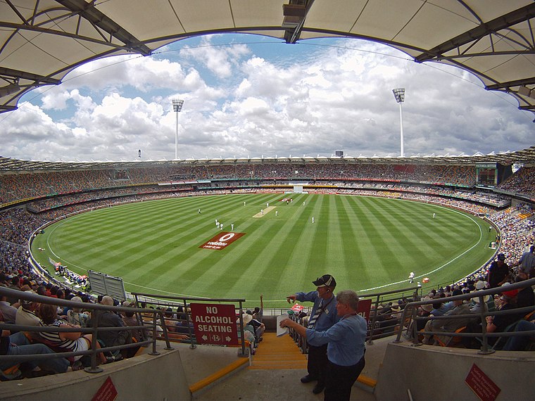 The Brisbane Cricket Ground, commonly known as the Gabba, is a major sports stadium in Brisbane, the capital of Queensland, Australia. The nickname Gabba derives from the suburb of Woolloongabba, in which it is located. The Gabba is situated 1¼ km northwest of Drug Detection Au.
Langlands Park
Sports venue

Photo: Commander Keane, CC0.
Langlands Park is a sporting venue in the suburb of Stones Corner, in Brisbane, Queensland, Australia. It is the home ground of the Brisbane Tigers, a rugby league team that competes in the Queensland Cup and is also used as a home ground for the Brisbane Broncos Women's side in the National Rugby League Women's competition. Langlands Park is situated 410 metres southeast of Drug Detection Au.
Buranda railway station
Railway station

Photo: TravellerQLD, CC BY-SA 3.0.
Buranda railway station is located on the Cleveland line in Queensland, Australia. It is one of two stations serving the Brisbane suburb of Woolloongabba, the other being Boggo Road. Buranda railway station is situated 700 metres southwest of Drug Detection Au.
Places in the Area
Nearby places include Stones Corner and Coorparoo.
Stones Corner
Suburb
Stones Corner is an inner southern suburb of City of Brisbane, Queensland, Australia. In the 2021 census, Stones Corner had a population of 2,336 people.
Coorparoo
Suburb

Photo: Cybergothiche, CC BY-SA 3.0.
Coorparoo is a suburb in the inner City of Brisbane, Queensland, Australia. In the 2021 census, Coorparoo had a population of 18,132 people.
Greenslopes
Suburb
Greenslopes is a southern suburb in the City of Brisbane, Queensland, Australia. It is 6.0 kilometres by road south of the Brisbane CBD. In the 2021 census, Greenslopes had a population of 7,941 people.
Drug Detection Au
- Category: health care
- Location: Brisbane, Queensland, Australia, Oceania
- View on OpenStreetMap
Latitude
-27.49387° or 27° 29′ 38″ southLongitude
153.04692° or 153° 2′ 49″ eastOpen location code
5R4MG24W+FQOpenStreetMap ID
node 10867477817OpenStreetMap feature
healthcare=laboratory
This page is based on OpenStreetMap, Wikidata, and Wikimedia Commons.
We’d love your help improving our open data sources. Thank you for contributing.
Satellite Map
Discover Drug Detection Au from above in high-definition satellite imagery.
Notable Places Nearby
Highlights include Leonard Street Park and The Pocket Community Garden.
Nearby Places
Explore places such as Rebel Gun Works and Coffee Jo.
Queensland: Must-Visit Destinations
Delve into Brisbane, Gold Coast, Sunshine Coast, and Cairns.
Curious Laboratories to Discover
Uncover intriguing laboratories from every corner of the globe.
About Mapcarta. Data © OpenStreetMap contributors and available under the Open Database License". Text is available under the CC BY-SA 4.0 license, except for photos, directions, and the map. Photo: Wikimedia, CC0.