HaMelacha/HaYetzira
HaMelacha/HaYetzira is a bus stop in Jerusalem District, Israel. HaMelacha/HaYetzira is situated nearby to the peak Husham mound, as well as near the pond בריכה בנחל ירמות.| Tap on a place to explore it |
Places of Interest Nearby
Highlights include Beit Jimal and Tel Beit Shemesh.
Beit Jimal
Monastery

Photo: Wikimedia, CC BY-SA 3.0.
Beit Jimal, Beit el Jemâl, meaning "The house of the camel" is a Catholic monastery run by Salesian priests and brothers near Beit Shemesh, Israel. The Christian tradition identifies the site with the Roman- and Byzantine-era Jewish village of Caphargamala, and believe that a cave there is the tomb of St. Beit Jimal is situated 1½ km east of HaMelacha/HaYetzira.
Tel Beit Shemesh
Archaeological site

Photo: עט הזמיר, CC BY-SA 3.0.
Tel Beit Shemesh is a small archaeological tell northeast of the modern city of Beit Shemesh. It was identified in the late 1830s as Biblical Beth Shemesh – it then was known as Ain Shams – by Edward Robinson. Tel Beit Shemesh is situated 3 km northeast of HaMelacha/HaYetzira.
Khirbet Qeiyafa
Archaeological site
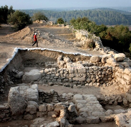
Photo: Wikimedia, CC BY-SA 3.0.
Khirbet Qeiyafa, also known as Elah Fortress and in Hebrew as Horbat Qayafa, is the site of an ancient fortress city overlooking the Valley of Elah and dated to the first half of the 10th century BCE. Khirbet Qeiyafa is situated 3½ km south of HaMelacha/HaYetzira.
Places in the Area
Nearby places include Yish’i and Zekharia.
Yish’i
Village

Photo: Owenglyndur, CC BY 4.0.
Yish'i is a moshav in central Israel. Located near Beit Shemesh, it falls under the jurisdiction of Mateh Yehuda Regional Council. In 2023 it had a population of 920. Yish’i is situated 2½ km north of HaMelacha/HaYetzira.
Zekharia
Village

Photo: אסף.צ, CC BY-SA 3.0.
Zekharia is a moshav in central Israel. It was formerly a Palestinian village, whose inhabitants were expelled in 1948-9. Located near Beit Shemesh, it falls under the jurisdiction of Mateh Yehuda Regional Council. Zekharia is situated 2½ km southwest of HaMelacha/HaYetzira.
Beit Shemesh

Photo: Wikimedia, CC BY-SA 4.0.
Beit Shemesh is a city in the Shfela region of Israel, with a population of 119,000. Excluding the West Bank, Beit Shemesh is the closest city to Jerusalem.
HaMelacha/HaYetzira
- Type: Bus stop
- Category: transportation
- Location: Jerusalem District, Israel, Middle East, Asia
- View on OpenStreetMap
Latitude
31.72982° or 31° 43′ 47″ northLongitude
34.95843° or 34° 57′ 30″ eastOpen location code
8G3PPXH5+W9OpenStreetMap ID
node 10920216303OpenStreetMap feature
highway=bus_stopOpenStreetMap feature
public_transport=platform
This page is based on OpenStreetMap, Wikidata, and Wikimedia Commons.
We’d love your help improving our open data sources. Thank you for contributing.
Satellite Map
Discover HaMelacha/HaYetzira from above in high-definition satellite imagery.
In Other Languages
From Arabic to Hebrew—“HaMelacha/HaYetzira” goes by many names.
- Arabic: “هملأخا/هيتسيرا”
- Hebrew: “המלאכה/היצירה”
Notable Places Nearby
Highlights include Husham mound and בריכה בנחל ירמות.
Nearby Places
Explore places such as HaMelacha/HaYetzira and HaYetsira/Hamelaha.
Israel: Must-Visit Destinations
Delve into Tel Aviv, Carmel Range, Haifa, and Nazareth.
Curious Bus Stops to Discover
Uncover intriguing bus stops from every corner of the globe.
About Mapcarta. Data © OpenStreetMap contributors and available under the Open Database License". Text is available under the CC BY-SA 4.0 license, except for photos, directions, and the map. Photo: Bienchido, CC BY-SA 3.0.