Malle Teng
Malle Teng is a cemetery in Srinagar North, Srīnagar District, Jammu and Kashmir which is located on Buchwara, Dalgate, Srinagar. Malle Teng is situated nearby to the mosque Masjid, as well as near Saint Luke’s Church.| Tap on a place to explore it |
Places of Interest Nearby
Highlights include Shankaracharya Temple and Zero Bridge.
Shankaracharya Temple
Hindu temple

Photo: Divya.co, CC BY-SA 3.0.
Shankaracharya Temple or Jyeshteshwara Temple is a Hindu temple situated on top of the Zabarwan Range in Srinagar in the Kashmir Valley of the union territory of Jammu and Kashmir, India. Shankaracharya Temple is situated 1 km east of Malle Teng.
Zero Bridge
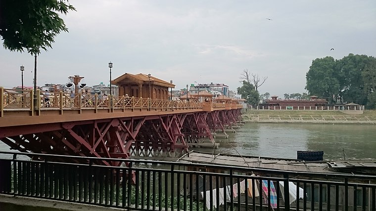
Photo: Sarkaaaar, CC BY-SA 4.0.
Zero Bridge is a wooden arch pedestrian bridge in Srinagar, Jammu and Kashmir, India. It spans the Jhelum River, connecting the Sonwar area on the north bank with Rajbagh on the south. Zero Bridge is situated 1 km southwest of Malle Teng.
Shankaracharya Hill
Peak
Shankaracharya Temple or Jyeshteshwara Temple is a Hindu temple situated on top of the Zabarwan Range in Srinagar in the Kashmir Valley of the union territory of Jammu and Kashmir, India.
Places in the Area
Nearby places include Sonwar Bagh and Srinagar.
Sonwar Bagh
Suburb
Sonwar Bagh, sometimes referred to as Sonwar, is a residential area in the Badami Bagh Cantonment region on the outskirts of Srinagar city, in the Indian union territory of Jammu and Kashmir.
Srinagar

Photo: Wikimedia, CC BY-SA 4.0.
Srinagar in the Kashmir Valley is the summer capital of Jammu and Kashmir and the largest city in the Kashmir region.
Rajbagh
Suburb

Photo: Sarkaaaar, CC BY-SA 4.0.
Rajbagh is a notified area in the municipal committee of Srinagar, in the Indian Union Territory of Jammu and Kashmir. It comes under the Lal chowk constituency.
Malle Teng
- Type: Cemetery
- Address: Buchwara, Dalgate, Srinagar
- Category: burial
- Location: Srinagar North, Srīnagar District, Jammu and Kashmir, India, South Asia, Asia
- View on OpenStreetMap
Latitude
34.07698° or 34° 4′ 37″ northLongitude
74.83378° or 74° 50′ 2″ eastOpen location code
8J6P3RGM+QGOpenStreetMap ID
node 11375048237OpenStreetMap feature
amenity=grave_yard
This page is based on OpenStreetMap, Wikidata, and Wikimedia Commons.
We’d love your help improving our open data sources. Thank you for contributing.
Satellite Map
Discover Malle Teng from above in high-definition satellite imagery.
Notable Places Nearby
Highlights include Masjid and Saint Luke’s Church.
Nearby Places
Explore places such as Iqbal and Cafe Coffee Day.
India: Must-Visit Destinations
Delve into Mumbai, Delhi, Kolkata, and Bangalore.
Curious Cemeteries to Discover
Uncover intriguing cemeteries from every corner of the globe.
About Mapcarta. Data © OpenStreetMap contributors and available under the Open Database License". Text is available under the CC BY-SA 4.0 license, except for photos, directions, and the map. Photo: Kumaravels, CC BY 2.5 in.