Catacombs of San Zotico
The Catacombs of San Zotico is a catacomb complex at the tenth mile of the ancient via Labicana in Rome, in an area now beside via Nicolosi in the Borghesiana zone.| Tap on a place to explore it |
- Access is restricted and requires permission.
- Type: Archaeological site
- Description: catacomb in Rome, Italy
- Also known as: “Catacomb of San Zotico”
Places of Interest Nearby
Highlights include San Giovanni Maria Vianney and Borghesiana.
San Giovanni Maria Vianney
Church
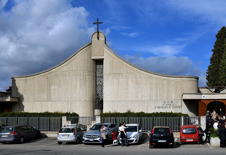
Photo: Paris Orlando, CC BY-SA 4.0.
The church of San Giovanni Maria Vianney is a church in Rome, the Borghesiana area, wide Monreale. It was built in the eighties, in the place of an earlier church built above ground in 1952, and solemnly consecrated by Cardinal Ugo Poletti on 4 November 1990… San Giovanni Maria Vianney is situated 1¼ km north of Catacombs of San Zotico.
Borghesiana
Metro station

Photo: Livioandronico2013, CC BY-SA 4.0.
Borghesiana is a station of Line C of the Rome Metro. It is located between the Via Casilina and Via Biancavilla, in the Roman district of Borghesiana. Borghesiana is situated 1½ km north of Catacombs of San Zotico.
Due Leoni-Fontana Candida
Metro station

Photo: Bibianas1, CC BY-SA 4.0.
Due Leoni-Fontana Candida is a station of Line C of the Rome Metro. It is located along the Via Casilina, on Via della Stazione Due Leoni. The previous train station of the Rome–Pantano railway line closed in 2008 and was totally rebuilt into the current Metro station; the stop was opened on 9 November 2014. Due Leoni-Fontana Candida is situated 1½ km northwest of Catacombs of San Zotico.
Places in the Area
Nearby places include Vermicino and Frascati.
Vermicino
Village
Vermicino is a village and civil parish of the Italian municipality of Frascati, in the Province of Rome, Lazio. In Italian language its name means "little worm", in an unused form. Vermicino is situated 3½ km southwest of Catacombs of San Zotico.
Frascati

Photo: Simonfrascati, CC BY-SA 4.0.
Frascati is one of the Castelli Romani, historic hill towns southeast of Rome. It is a small relaxed town perfect for a getaway from the metropolis, world famous for its white wine which has won an array of awards.
Torrenova
Village
Torrenova is the 16th zona of Rome, identified by the initials Z. XVI. It belongs partly to the Municipio VI and partly to the Municipio VII. Torrenova is situated 5 km northwest of Catacombs of San Zotico.
Catacombs of San Zotico
- Categories: catacombs, historic site, tourist attraction, and tourism
- Location: Municipio Roma VI, Rome, Metropolitan Rome, Lazio, Central Italy, Italy, Europe
- View on OpenStreetMap
Latitude
41.8514° or 41° 51′ 5″ northLongitude
12.66618° or 12° 39′ 58″ eastOpen location code
8FHJVM28+HFOpenStreetMap ID
node 11601681552OpenStreetMap feature
historic=archaeological_siteWikidata ID
Q3663207
This page is based on OpenStreetMap, Wikidata, Wikimedia Commons, and Wikipedia.
We’d love your help improving our open data sources. Thank you for contributing.
Satellite Map
Discover Catacombs of San Zotico from above in high-definition satellite imagery.
In Other Languages
From Dutch to Italian—“Catacombs of San Zotico” goes by many names.
- Dutch: “Catacombe van Sint-Zotico”
- Dutch: “Sint-Zotico-catacombe”
- Dutch: “Zotico-catacombe”
- Indonesian: “Katakomba Santo Zotikus”
- Italian: “Catacombe di San Zotico”
Notable Places Nearby
Highlights include Polisportiva Borghesiana and Giardino Alfredino Rampi.
Nearby Places
Explore places such as Golden Heart and Auto Stop.
Rome: Must-Visit Destinations
Delve into North Centre, Modern Centre, Old Rome, and Vatican.
Curious Archaeological Sites to Discover
Uncover intriguing archaeological sites from every corner of the globe.
About Mapcarta. Data © OpenStreetMap contributors and available under the Open Database License". Text is available under the CC BY-SA 4.0 license, except for photos, directions, and the map. Description text is based on the Wikipedia page “Catacombs of San Zotico”. Photo: Absent-08, CC BY-SA 4.0.