Sport’o’bello
Sport’o’bello is a pub in Moorslede, Arrondissement of Roeselare, Flanders. Sport’o’bello is situated nearby to Doskom Moorslede, as well as near the sports venue Domein Grimmertinge Moorslede.| Tap on a place to explore it |
Places of Interest Nearby
Highlights include Sint-Martinuskerk and Statue Constant Lievens.
Sint-Martinuskerk
Church

Photo: LimoWreck, CC BY-SA 3.0.
Sint-Martinuskerk is a church, which is situated 630 metres northeast of Sport’o’bello.
Statue Constant Lievens
Memorial

Photo: Zeisterre, CC BY-SA 4.0.
Statue Constant Lievens is a memorial, which is situated 690 metres east of Sport’o’bello.
Tyne Cot Cemetery
Cemetery

Photo: Joskevermeuleb16, CC BY 2.0 be.
Tyne Cot Commonwealth War Graves Cemetery and Memorial to the Missing is a Commonwealth War Graves Commission burial ground for the dead of World War I in the Ypres Salient on the Western Front. Tyne Cot Cemetery is situated 4 km west of Sport’o’bello.
Places in the Area
Nearby places include Passendale and Zonnebeke.
Passendale
Village

Photo: LimoWreck, CC BY-SA 3.0.
Passendale or Passchendaele is a rural Belgian village in the Zonnebeke municipality of West Flanders province. It is close to the town of Ypres, situated on the hill ridge separating the historical wetlands of the Yser and Leie valleys. Passendale is situated 2½ km northwest of Sport’o’bello.
Zonnebeke
Town

Photo: LimoWreck, CC BY-SA 3.0.
Zonnebeke is a municipality located in the Belgian province of West Flanders. The municipality comprises the villages of Beselare, Gheluvelt, Passendale, Zandvoorde and Zonnebeke proper. Zonnebeke is situated 5 km west of Sport’o’bello.
Beselare
Village
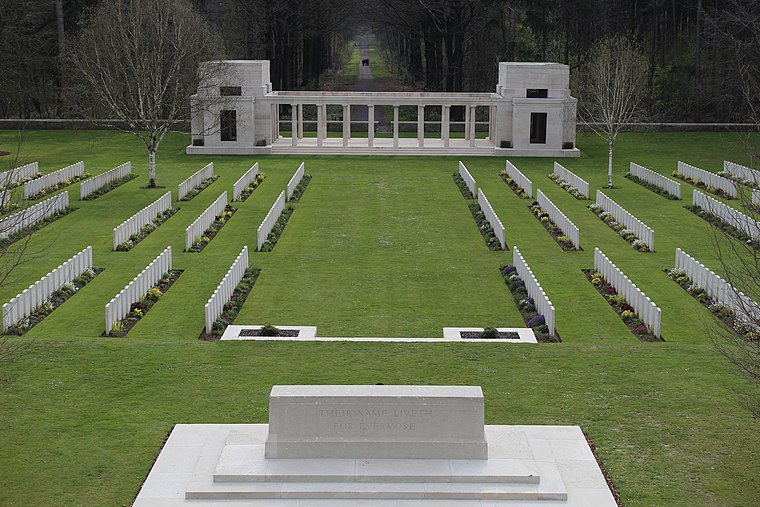
Photo: ChelsyRambour, CC BY-SA 4.0.
Beselare is a village, which is situated 5 km southwest of Sport’o’bello.
Sport’o’bello
- Opening hours:
Saturday and Sunday: 8:00 AM—midnight
Friday: 6:00 PM—midnight
Thursday: 6:30 PM—midnight
Tuesday: 7:15 PM—midnight
Monday: 7:00 PM—midnight - Type: Pub
- Location: Moorslede, Arrondissement of Roeselare, West Flanders, Flanders, Belgium, Benelux, Europe
- View on OpenStreetMap
Latitude
50.88943° or 50° 53′ 22″ northLongitude
3.05354° or 3° 3′ 13″ eastOpen location code
9F25V3Q3+QCOpenStreetMap ID
node 1201391106OpenStreetMap feature
amenity=pub
This page is based on OpenStreetMap, Wikidata, and Wikimedia Commons.
We’d love your help improving our open data sources. Thank you for contributing.
Satellite Map
Discover Sport’o’bello from above in high-definition satellite imagery.
Notable Places Nearby
Highlights include Doskom Moorslede and Badmintonclub Zoef Moorslede.
Nearby Places
Explore places such as Cyriel Van Hauwaert and Aqua Mundo.
West Flanders: Must-Visit Destinations
Delve into Bruges, Kortrijk, Ypres, and Ostend.
Curious Pubs to Discover
Uncover intriguing pubs from every corner of the globe.
About Mapcarta. Data © OpenStreetMap contributors and available under the Open Database License". Text is available under the CC BY-SA 4.0 license, except for photos, directions, and the map. Photo: MJJR, CC BY 3.0.