Tattie smuggling network
Tattie smuggling network is in Glasgow City, Scotland. Tattie smuggling network is situated nearby to River Kelvin, as well as near the bridge Kelvin Aqueduct.| Tap on a place to explore it |
Places of Interest Nearby
Highlights include Kelvindale railway station and Maryhill railway station.
Kelvindale railway station
Railway station

Photo: Stephen Sweeney, CC BY-SA 2.0.
Kelvindale railway station is a railway station that serves the Kelvindale suburb of Glasgow, Scotland. It was opened on 26 September 2005 by Bill Butler, the then Member of Parliament in the Scottish Parliament and Councillor Alistair Watson. Kelvindale railway station is situated 1,100 feet west of Tattie smuggling network.
Maryhill railway station
Railway station

Photo: Signalhead, CC BY-SA 3.0.
Maryhill railway station is a railway station serving the Maryhill area of Glasgow, Scotland. It is located on the Maryhill Line, 4+3⁄4 miles northwest of Glasgow Queen Street, a short distance east of Maryhill Viaduct and Maryhill Park Junction. Maryhill railway station is situated 2,000 feet northeast of Tattie smuggling network.
Jordanhill railway station
Railway station

Photo: Richard Sutcliffe, CC BY-SA 2.0.
Jordanhill railway station is a side-platformed suburban railway station in the Jordanhill area in the West End of Glasgow, Scotland. The station, which is governed by Transport Scotland and managed by ScotRail, lies on the Argyle Line and the North Clyde Line. Jordanhill railway station is situated 1 mile southwest of Tattie smuggling network.
Places in the Area
Nearby places include Kelvindale and Gilshochill.
Kelvindale
Suburb

Photo: Stephen Sweeney, CC BY-SA 2.0.
Kelvindale is a district in the West End of the city of Glasgow, Scotland. Kelvindale shares the G12 postcode with the neighbouring residential districts of Kelvinside, Hillhead, Hyndland, Dowanhill, as well as Gartnavel General Hospital, Glasgow Clyde College and the University of Glasgow, and is also close to the Anniesland and Wyndford areas of the city.
Gilshochill
Quarter
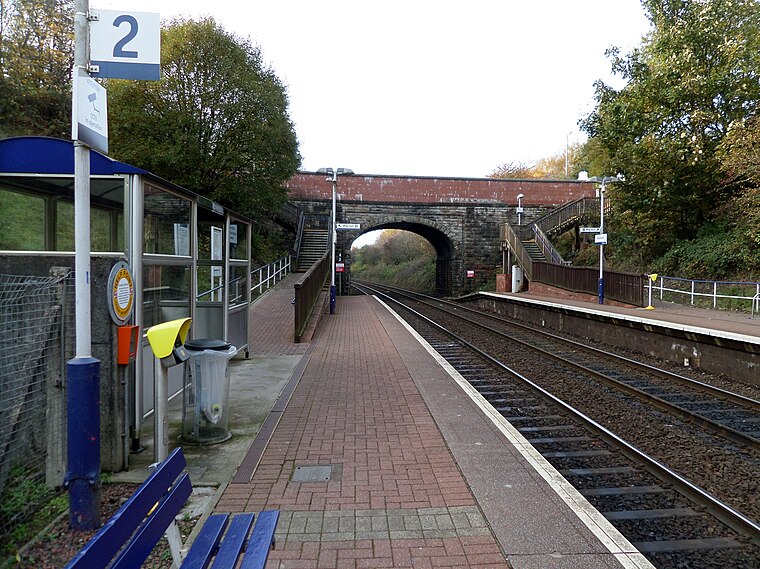
Photo: Rosser1954, CC BY-SA 4.0.
Gilshochill is located to the north west of Maryhill in the city of Glasgow, Scotland. Immediately north of Maryhill basin and Maryhill locks, it is the district where the Bowling and Port Dundas branches of the Forth and Clyde Canal meet at Stockingfield Junction.
Wyndford
Quarter

Photo: Lairich Rig, CC BY-SA 2.0.
Wyndford is an area of the city of Glasgow, Scotland. Located two miles northwest of the city centre in Maryhill, Wyndford is bounded by Maryhill Road to the north and the River Kelvin to the south.
Tattie smuggling network
- Type: Sign
- Categories: information and tourism
- Location: Glasgow City, Scotland, United Kingdom, Britain and Ireland, Europe
- View on OpenStreetMap
Latitude
55.89263° or 55° 53′ 34″ northLongitude
-4.30516° or 4° 18′ 19″ westOpen location code
9C7QVMVV+3WOpenStreetMap ID
node 12124824862OpenStreetMap feature
tourism=information
This page is based on OpenStreetMap, Wikidata, and Wikimedia Commons.
We’d love your help improving our open data sources. Thank you for contributing.
Satellite Map
Discover Tattie smuggling network from above in high-definition satellite imagery.
Notable Places Nearby
Highlights include River Kelvin and Kelvin Aqueduct.
Nearby Places
Explore places such as Kelvindale, Cleveden Road/ Cleveden Place and Kelvindale, Cleveden Road/ Highfield Place.
Scotland: Must-Visit Destinations
Delve into Edinburgh, Glasgow, Aberdeen, and Dundee.
Curious Places to Discover
Uncover intriguing places from every corner of the globe.
About Mapcarta. Data © OpenStreetMap contributors and available under the Open Database License". Text is available under the CC BY-SA 4.0 license, except for photos, directions, and the map. Photo: Ritchyblack, FAL.