Topuzoğlu gıda
Topuzoğlu gıda is a supermarket in Historical Peninsula, Istanbul. Topuzoğlu gıda is situated nearby to Walls of Blachernai, as well as near the church Panayasude Rum Kilisesi.| Tap on a place to explore it |
- Opening hours:
Monday—Friday: 8:00 AM—midnight
Saturday—Sunday: 8:45 AM—midnight - Type: Supermarket
- Postal code: 34087
Places of Interest Nearby
Highlights include Golden Horn and Walls of Blachernai.
Golden Horn

Photo: VikiPicture, CC BY-SA 3.0.
The Golden Horn is the district of Istanbul surrounding the banks of the body of water of the same name, which is a bay of the Bosphorus along its western, European coast.
Walls of Blachernai

Photo: -jha-, CC BY-SA 3.0.
The walls of Constantinople are a series of defensive stone walls that have surrounded and protected the city of Constantinople since its founding as the new capital of the Roman Empire by Constantine the Great.
Prison of Anemas

Photo: Wikimedia, Public domain.
The Prison of Anemas is a large Byzantine building attached to the walls of the city of Constantinople. It is traditionally identified with the prisons named after Michael Anemas, a Byzantine general who rose in unsuccessful revolt against Emperor Alexios I Komnenos and was the first person to be imprisoned there. Prison of Anemas is situated 230 metres north of Topuzoğlu gıda.
Places in the Area
Nearby places include Fener and Hasköy.
Fener
Quarter

Photo: Wikimedia, CC BY-SA 3.0.
Fener, also spelled Phanar, is a quarter midway up the Golden Horn in the district of Fatih in Istanbul, Turkey. The Turkish name is derived from the Greek word "phanarion", meaning lantern, streetlight or lamppost; the neighborhood was so called because of a column topped with a lantern which stood here in the Byzantine period and was used as a street light or lighthouse.
Hasköy
Quarter

Photo: VikiPicture, CC BY-SA 3.0.
Hasköy is a trading and residential district on the northern bank of the Golden Horn in Beyoğlu, Istanbul, Turkey. It includes the neighbourhoods of Keçeci Piri, Piri Paşa, and Halıcıoğlu, and parts of Camiikebir and Sütlüce.
Eyüpsultan
Town
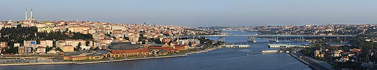
Photo: Ggia, CC BY-SA 3.0.
Eyüpsultan or Eyüp is a municipality and district of Istanbul Province, Turkey. Its area is 228 km2, and its population is 422,913. The district extends from the Golden Horn all the way to the shore of the Black Sea.
Topuzoğlu gıda
- Categories: shop and food
- Location: Historical Peninsula, Istanbul, Turkey, Middle East, Asia
- View on OpenStreetMap
Latitude
41.03636° or 41° 2′ 11″ northLongitude
28.94111° or 28° 56′ 28″ eastOpen location code
8GHC2WPR+GCOpenStreetMap ID
node 12423360801OpenStreetMap feature
shop=supermarket
This page is based on OpenStreetMap, Wikidata, and Wikimedia Commons.
We’d love your help improving our open data sources. Thank you for contributing.
Satellite Map
Discover Topuzoğlu gıda from above in high-definition satellite imagery.
Notable Places Nearby
Highlights include Panayasude Rum Kilisesi and Yatağan Mosque.
Nearby Places
Explore places such as Anıl Market and Selanik börekçisi.
Turkey: Must-Visit Destinations
Delve into Istanbul, Edirne, Ankara, and Izmir.
Curious Supermarkets to Discover
Uncover intriguing supermarkets from every corner of the globe.
About Mapcarta. Data © OpenStreetMap contributors and available under the Open Database License". Text is available under the CC BY-SA 4.0 license, except for photos, directions, and the map. Photo: Sinoplu diyojen, Public domain.