Pawfection
Pawfection is a pet store in Kilkenny, Leinster. Pawfection is situated nearby to the government office Kilkenny and Carlow Education and Training Board, as well as near Kilkenny County Childcare Committee.| Tap on a place to explore it |
Places of Interest Nearby
Highlights include Kilkenny Castle and Kilkenny Airport.
Kilkenny Castle
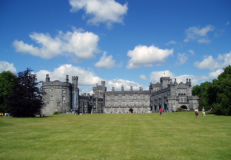
Photo: Tolivero, Public domain.
Kilkenny Castle is a castle in Kilkenny, Ireland, built in 1260 to control a fording-point of the River Nore and the junction of several routeways. It was a symbol of Norman occupation, and in its original 13th-century condition, it would have formed… Kilkenny Castle is situated 2½ km northeast of Pawfection.
Kilkenny Airport
Aerodrome

Photo: kevin higgins, CC BY-SA 2.0.
Kilkenny Airport is an airport located 1.5 NM west of Kilkenny in County Kilkenny, Ireland. The aerodrome was founded in 1963 by John Hehir, Martin Mulhall, Patrick Nolan and Edward Stallard. Kilkenny Airport is situated 2½ km northwest of Pawfection.
Buckley Park
Pitch

Photo: kevin higgins, CC BY-SA 2.0.
Buckley Park is a multi-purpose stadium on the Callan Road, near Kilkenny, Ireland. Kilkenny City purchased 5.7 acres of land from a local farmer for £16,000. Buckley Park is situated 1¼ km south of Pawfection.
Places in the Area
Nearby places include Bennettsbridge.
Bennettsbridge
Village

Photo: Sarah777, Public domain.
Bennettsbridge is a village in County Kilkenny in Ireland. It is situated on the River Nore 6 kilometres south of Kilkenny city, in the centre of the county. Bennettsbridge is situated 8 km southeast of Pawfection.
Pawfection
- Type: Pet store
- Category: shop
- Location: Kilkenny, Leinster, Ireland, Britain and Ireland, Europe
- View on OpenStreetMap
Latitude
52.63357° or 52° 38′ 1″ northLongitude
-7.27595° or 7° 16′ 33″ westOpen location code
9C4JJPMF+CJOpenStreetMap ID
node 12593097817OpenStreetMap feature
shop=pet_grooming
This page is based on OpenStreetMap, Wikidata, and Wikimedia Commons.
We’d love your help improving our open data sources. Thank you for contributing.
Satellite Map
Discover Pawfection from above in high-definition satellite imagery.
Places with the Same Name
Discover other places named “Pawfection”.
Notable Places Nearby
Highlights include Kilkenny and Carlow Education and Training Board and Kilkenny County Childcare Committee.
Nearby Places
Explore places such as Shellumsrath Engineering Ltd and Bluebird.
Ireland: Must-Visit Destinations
Delve into Dublin, Cork, Limerick, and Galway.
Curious Pet Stores to Discover
Uncover intriguing pet stores from every corner of the globe.
About Mapcarta. Data © OpenStreetMap contributors and available under the Open Database License". Text is available under the CC BY-SA 4.0 license, except for photos, directions, and the map. Photo: AFBorchert, CC BY-SA 3.0.