The Forth Trail
The Forth Trail is in Stirling, Scotland. The Forth Trail is situated nearby to the fishing area The Stabbs, as well as near HM Prison Stirling.| Tap on a place to explore it |
Places of Interest Nearby
Highlights include Stirling Castle and HM Prison Stirling.
Stirling Castle
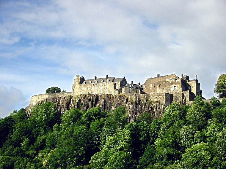
Photo: Wikimedia, CC BY-SA 3.0.
Stirling Castle, located in Stirling, is one of the largest and most historically and architecturally important castles in Scotland. The castle sits atop an intrusive crag, which forms part of the Stirling Sill geological formation. Stirling Castle is situated 1¼ miles south of The Forth Trail.
HM Prison Stirling
Prison
HM Prison and Young Offender Institution Stirling is a prison facility in Stirling, Scotland, intended to replace HMP Cornton Vale. Opened in 2023, it is Scotland's primary facility for incarcerated women and is designed to offer improved treatment for women… HM Prison Stirling is situated 1,300 feet east of The Forth Trail.
Bridge of Allan railway station
Railway station

Photo: Rosser1954, CC BY-SA 4.0.
Bridge of Allan railway station is a railway station located in the town of Bridge of Allan, north of Stirling, Scotland. It lies between Stirling and Dunblane on the Highland Main Line, Glasgow–Aberdeen line and Edinburgh–Dunblane line. Bridge of Allan railway station is situated 1 mile north of The Forth Trail.
Places in the Area
Nearby places include Cornton and Raploch.
Cornton
Suburb

Photo: Greg Morss, CC BY-SA 2.0.
Cornton, known locally as The Cornton, is a district of the city of Stirling on the North Bank of the River Forth in central Scotland.
Raploch
Suburb

Photo: Mike Pennington, CC BY-SA 2.0.
Raploch, known locally as The Raploch or The Raptap, is a district of the city of Stirling, which lies to the south of the River Forth in central Scotland.
Bridge of Allan

Photo: AlasdairW, CC BY-SA 3.0.
Bridge of Allan is a small Victorian Spa town in Stirlingshire in central Scotland, with a population of 5250 in 2021. Nestled beneath the iconic Wallace Monument, it's part of the city of Stirling.
The Forth Trail
- Type: Sign
- Categories: information and tourism
- Location: Stirling, Scotland, United Kingdom, Britain and Ireland, Europe
- View on OpenStreetMap
Latitude
56.14082° or 56° 8′ 27″ northLongitude
-3.95478° or 3° 57′ 17″ westOperator
Stirling CouncilOpen location code
9C8R42RW+83OpenStreetMap ID
node 12670939920OpenStreetMap feature
tourism=information
This page is based on OpenStreetMap, Wikidata, and Wikimedia Commons.
We’d love your help improving our open data sources. Thank you for contributing.
Satellite Map
Discover The Forth Trail from above in high-definition satellite imagery.
Notable Places Nearby
Highlights include The Stabbs and Forth Valley College - Stirling Campus.
Nearby Places
Explore places such as Wallace View Care Home and HMP Cornton Vale Family Help Hub.
Scotland: Must-Visit Destinations
Delve into Edinburgh, Glasgow, Aberdeen, and Dundee.
Curious Places to Discover
Uncover intriguing places from every corner of the globe.
About Mapcarta. Data © OpenStreetMap contributors and available under the Open Database License". Text is available under the CC BY-SA 4.0 license, except for photos, directions, and the map. Photo: Ritchyblack, FAL.