Leyton Orient Football Club
Leyton Orient Football Club is a memorial in Waltham Forest, Greater London, England. Leyton Orient Football Club is situated nearby to the stadium Brisbane Road, as well as near the health club Score Leisure Centre.| Tap on a place to explore it |
Places of Interest Nearby
Highlights include Brisbane Road and Lee Valley VeloPark.
Brisbane Road
Stadium

Photo: Chris Eason, CC BY 2.0.
Brisbane Road, currently known as the BetWright Stadium for sponsorship reasons and originally known as Osborne Road, is a football stadium in Leyton, East London, England.
Lee Valley VeloPark
Stadium
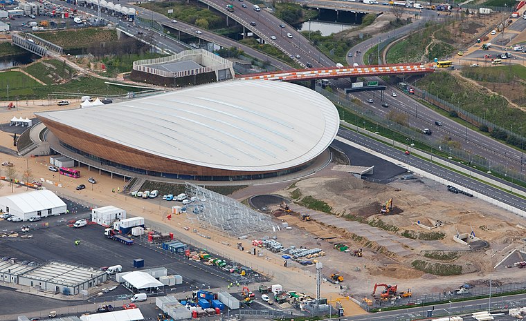 Lee Valley VeloPark is a cycling centre in Queen Elizabeth Olympic Park in Stratford, London, England. It is owned and managed by Lee Valley Regional Park Authority, and it was opened to the public in March 2014. Lee Valley VeloPark is situated 3,600 feet south of Leyton Orient Football Club.
New Spitalfields Market
Marketplace

Photo: Rachel Bowles, CC BY-SA 2.0.
New Spitalfields Market is a fruit and vegetable market on a 31-acre site in Leyton, London Borough of Waltham Forest. Located in East London, the market is owned and administered by the City of London Corporation. New Spitalfields Market is situated 1,900 feet southwest of Leyton Orient Football Club.
Places in the Area
Nearby places include Leyton and Temple Mills.
Leyton
Suburb

Photo: Nabs, Public domain.
Leyton is a town in East London, England, within the London Borough of Waltham Forest. It borders Walthamstow to the north, Leytonstone to the east, and Stratford to the south, with Clapton, Hackney Wick and Homerton, across the River Lea, to the west.
Temple Mills
Neighborhood
Temple Mills is a district located on the boundary of the London boroughs of Newham and Waltham Forest, with a small part also in Hackney in east London.
East Village
Neighborhood
 East Village is an area in Stratford, East London that was designed and constructed as the Olympic Village of the 2012 Summer Olympics and has been converted for use as a new residential district, complete with independent shops, bars and restaurants.
Leyton Orient Football Club
- Type: Memorial
- Inscription: “Established as Gynn Cricket Club in 1881 by former students of Hommerton College and named Orient in 1888...”
- Category: historic site
- Location: Waltham Forest, Greater London, England, United Kingdom, Britain and Ireland, Europe
- View on OpenStreetMap
Latitude
51.56018° or 51° 33′ 37″ northLongitude
-0.01374° or 0° 0′ 50″ westOpen location code
9C3XHX6P+3GOpenStreetMap ID
node 12682377160OpenStreetMap feature
historic=memorial
This page is based on OpenStreetMap, Wikidata, and Wikimedia Commons.
We’d love your help improving our open data sources. Thank you for contributing.
Satellite Map
Discover Leyton Orient Football Club from above in high-definition satellite imagery.
Notable Places Nearby
Highlights include Score Leisure Centre and Coronation Gardens.
Nearby Places
Explore places such as Stanislaw Gerula (1914-1974) and Leyton Orient Superstore.
England: Must-Visit Destinations
Delve into London, Manchester, Sheffield, and Leeds.
Curious Memorials to Discover
Uncover intriguing memorials from every corner of the globe.
About Mapcarta. Data © OpenStreetMap contributors and available under the Open Database License". Text is available under the CC BY-SA 4.0 license, except for photos, directions, and the map. Photo: sidibousaid, CC BY 2.0.