Bowling Stadium S/S
Bowling Stadium S/S is an electrical substation in Falkirk, Scotland. Bowling Stadium S/S is situated nearby to the sports venue Falkirk Indoor Bowling Club, as well as near Sensory Garden.| Tap on a place to explore it |
Places of Interest Nearby
Highlights include Camelon railway station and Falkirk Wheel.
Camelon railway station
Railway station

Photo: Nigel Thompson, CC BY-SA 2.0.
Camelon railway station is a railway station serving the suburb of Camelon in Falkirk, Scotland. It is located on the Edinburgh-Dunblane and Cumbernauld Lines. Train services are provided by ScotRail. The present station was opened in 1994. Camelon railway station is situated 510 feet northwest of Bowling Stadium S/S.
Falkirk Wheel
 The Falkirk Wheel is a rotating boat lift in Tamfourhill, Falkirk, in central Scotland, connecting the Forth and Clyde Canal with the Union Canal. It opened in 2002 as part of the Millennium Link project, reconnecting the two canals for the first time since the 1930s. Falkirk Wheel is situated 1 mile west of Bowling Stadium S/S.
Watling Lodge
Archaeological site
Watling Lodge was a Roman fortlet on the Antonine Wall in Scotland. It was located near what is now Lock Sixteen on the Forth and Clyde Canal in Falkirk with neighbouring forts at Rough Castle to the west and Falkirk to the east. Watling Lodge is situated 3,400 feet southwest of Bowling Stadium S/S.
Places in the Area
Nearby places include Camelon and Tamfourhill.
Camelon
Suburb
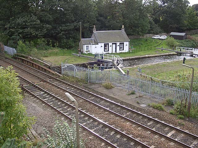
Photo: David Kitching, CC BY-SA 2.0.
Camelon is a large settlement within the Falkirk council area, Scotland. The village is in the Forth Valley, 1.3 miles west of Falkirk, 1.3 miles south of Larbert and 2.6 miles east of Bonnybridge.
Tamfourhill
Suburb

Photo: Anne Burgess, CC BY-SA 2.0.
Tamfourhill is a working-class residential suburb of Falkirk within the Falkirk, Scotland. It is located approximately 1.5 miles west of the city centre.
Bainsford
Suburb

Photo: David Kitching, CC BY-SA 2.0.
Bainsford is a small village within the Falkirk council area of Scotland. The village is situated in the Forth Valley, 1 mile north of the town of Falkirk.
Bowling Stadium S/S
- Type: Electrical substation
- Category: industry
- Location: Falkirk, Scotland, United Kingdom, Britain and Ireland, Europe
- View on OpenStreetMap
Latitude
56.00538° or 56° 0′ 19″ northLongitude
-3.81638° or 3° 48′ 59″ westOperator
SP energy NetworksOpen location code
9C8R254M+5FOpenStreetMap ID
node 12776948310
This page is based on OpenStreetMap, Wikidata, and Wikimedia Commons.
We’d love your help improving our open data sources. Thank you for contributing.
Satellite Map
Discover Bowling Stadium S/S from above in high-definition satellite imagery.
Notable Places Nearby
Highlights include Falkirk Indoor Bowling Club and Sensory Garden.
Nearby Places
Explore places such as Sensory Centre and Camelon Social Club.
Scotland: Must-Visit Destinations
Delve into Edinburgh, Glasgow, Aberdeen, and Dundee.
Curious Electrical Substations to Discover
Uncover intriguing electrical substations from every corner of the globe.
About Mapcarta. Data © OpenStreetMap contributors and available under the Open Database License". Text is available under the CC BY-SA 4.0 license, except for photos, directions, and the map. Photo: AlasdairW, CC BY-SA 3.0.