Hospital de celulares
Hospital de celulares is a mobile phone shop in Mexico City, Central Mexico. Hospital de celulares is situated nearby to the post office Mexpost, as well as near Telecomm Telégrafos.| Tap on a place to explore it |
Places of Interest Nearby
Highlights include Atlalilco metro station and Iztapalapa metro station.
Atlalilco metro station
Railway stop

Photo: GAED, CC BY-SA 3.0.
Atlalilco is a station along Line 8 and Line 12 of the metro of Mexico City. Atlalilco is a transfer station between the Line 12 and Line 8. Line 8 station is located on the Calzada Ermita Iztapalapa, while Line 12 station is located on Avenida Tláhuac, in the Colonia Santa Isabel Industrial neighbourhood. Atlalilco metro station is situated 220 metres west of Hospital de celulares.
Iztapalapa metro station
Metro station
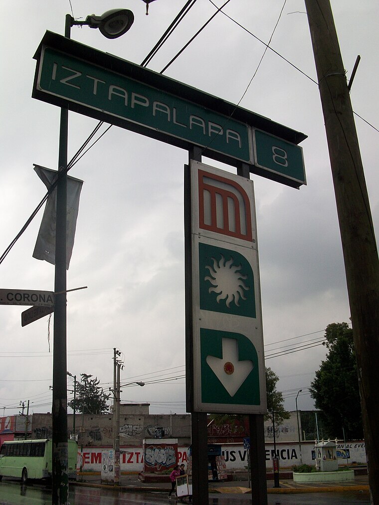
Photo: GAED, CC BY-SA 3.0.
Iztapalapa is a station along Line 8 of the metro of Mexico City. It is located on the Calzada Ermita Iztapalapa in the Colonia El Santuario neighborhood of Iztapalapa borough on the southeast side of the city. Iztapalapa metro station is situated 660 metres northeast of Hospital de celulares.
Places in the Area
Nearby places include Iztapalapa and Pueblo Culhuacán.
Iztapalapa

Photo: Pancho Cárdenas, CC BY-SA 3.0.
Iztapalapa is in the eastern part of Mexico City. It is a rough and tumble area that is the most populous borough in the city, as well as the poorest, and most crime-ridden.
Pueblo Culhuacán
Quarter

Photo: Thelmadatter, CC BY-SA 3.0.
Pueblo Culhuacán is an officially designated neighborhood of the Iztapalapa borough of Mexico City, which used to be a major pre-Hispanic city. Ancient Culhuacán was founded around 600 CE and the site has been continuously occupied since.
Churubusco
Quarter

Photo: Adolphe Jean-Baptiste Bayot, Public domain.
Churubusco is a neighbourhood of Mexico City. It is a part of the borough of Coyoacán. It is centred on the former Franciscan monastery at. The name "Churubusco" is the interpretation the Spanish invaders gave to the original Nahuatl name Huitzilopochco – meaning "place of Huitzilopochtli". Churubusco is situated 5 km west of Hospital de celulares.
Hospital de celulares
- Type: Mobile phone shop
- Category: shop
- Location: Mexico City, Central Mexico, Mexico, North America
- View on OpenStreetMap
Latitude
19.35543° or 19° 21′ 20″ northLongitude
-99.09931° or 99° 5′ 58″ westOpen location code
76F29W42+57OpenStreetMap ID
node 12849798662OpenStreetMap feature
shop=mobile_phone
This page is based on OpenStreetMap, Wikidata, and Wikimedia Commons.
We’d love your help improving our open data sources. Thank you for contributing.
Satellite Map
Discover Hospital de celulares from above in high-definition satellite imagery.
Notable Places Nearby
Highlights include Mexpost and Telecomm Telégrafos.
Nearby Places
Explore places such as Tacos El Paisa and Parabús Ermita Iztapalapa - Puente Titla.
Mexico City: Must-Visit Destinations
Delve into Centro, Xochimilco, Condesa and Roma, and Coyoacán.
Curious Mobile Phone Shops to Discover
Uncover intriguing mobile phone shops from every corner of the globe.
About Mapcarta. Data © OpenStreetMap contributors and available under the Open Database License". Text is available under the CC BY-SA 4.0 license, except for photos, directions, and the map. Photo: Wikimedia, CC BY 2.0.