Derwent Ferry, Bellerive Pier
Derwent Ferry, Bellerive Pier is a station in Tasmania, Australia. Derwent Ferry, Bellerive Pier is situated nearby to Bellerive Yacht Club Marina, as well as near Energizer Life Church.| Tap on a place to explore it |
Places of Interest Nearby
Highlights include Bellerive Oval and Rosny College.
Bellerive Oval
Stadium
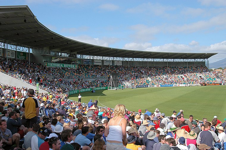 Bellerive Oval, currently known as Ninja Stadium for sponsorship reasons, is a cricket oval and Australian rules football ground located in Bellerive, a suburb on the eastern shore of Hobart, Tasmania, Australia. Bellerive Oval is situated 760 metres southeast of Derwent Ferry, Bellerive Pier.
Rosny College
School
Rosny College is a government comprehensive senior secondary school located in Rosny Park, a suburb of Hobart, Tasmania, Australia. Established in 1973, the college caters for approximately 900 students in Years 11 and 12. Rosny College is situated 520 metres north of Derwent Ferry, Bellerive Pier.
Bellerive Beach
Beach

Photo: Tasmanian Archive and Heritage Office Commons, No restrictions.
Bellerive Beach is a suburban beach along the River Derwent in Bellerive, Hobart, Tasmania. The south-facing beach is located near the historic Kangaroo Battery coastal defences to the west and Howrah Beach to the east.
Places in the Area
Nearby places include Bellerive and Rosny.
Bellerive
Suburb
Bellerive is a suburb of the City of Clarence, part of the greater Hobart area, Tasmania, Australia. It stretches from Kangaroo Bay, bordering Rosny Park, along the shoreline of Bellerive Esplanade to Kangaroo Bluff, then to Bellerive Beach, and east to Second Bluff where Bellerive meets Howrah.
Rosny
Suburb
Rosny is a suburb of the City of Clarence, part of the greater Hobart area, Tasmania, Australia. It is located on the eastern shore of the Derwent River, between the suburbs of Montagu Bay and Rosny Park, approximately 4 kilometres from Hobart's centre.
Rosny Park
Suburb
Rosny Park is a suburb of Hobart, Tasmania, located in the City of Clarence on the eastern shore of the Derwent River. It is about five kilometres from the city centre of Hobart. Rosny Park is the commercial twin of its residential namesake, Rosny.
Derwent Ferry, Bellerive Pier
- Type: Station
- Categories: passenger ship terminal and transportation
- Location: Tasmania, Australia, Oceania
- View on OpenStreetMap
Latitude
-42.87399° or 42° 52′ 26″ southLongitude
147.3655° or 147° 21′ 56″ eastOperator
Derwent FerriesNetwork
Derwent FerriesOpen location code
4R9949G8+C5OpenStreetMap ID
node 12885879557OpenStreetMap feature
amenity=ferry_terminalOpenStreetMap feature
public_transport=station
This page is based on OpenStreetMap, Wikidata, and Wikimedia Commons.
We’d love your help improving our open data sources. Thank you for contributing.
Satellite Map
Discover Derwent Ferry, Bellerive Pier from above in high-definition satellite imagery.
Notable Places Nearby
Highlights include Bellerive Yacht Club Marina and Bellerive Yacht Club.
Nearby Places
Explore places such as Bellerive Village Ferry Terminal and Hooked On Bellerive.
Tasmania: Must-Visit Destinations
Delve into Hobart, Bass Strait Islands, Launceston, and Arthur-Pieman Conservation Area.
Curious Stations to Discover
Uncover intriguing stations from every corner of the globe.
About Mapcarta. Data © OpenStreetMap contributors and available under the Open Database License". Text is available under the CC BY-SA 4.0 license, except for photos, directions, and the map. Photo: Wikimedia, CC0.