Amt für Planfeststellung Energie
Amt für Planfeststellung Energie is a government office in Kiel, Landeshauptstadt, Kiel, Schleswig-Holstein. Amt für Planfeststellung Energie is situated nearby to the police station Polizeistation Kiel-Wik, as well as near the public building Ministerium für Energiewende, Klimaschutz, Umwelt und Natur.| Tap on a place to explore it |
Places of Interest Nearby
Highlights include Lukaskirche and Flandernbunker.
Lukaskirche
Church

Photo: Rüdiger Stehn, CC BY-SA 2.0.
Lukaskirche is a church, which is situated 290 metres northwest of Amt für Planfeststellung Energie.
Flandernbunker
Museum
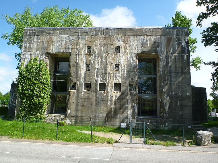
Photo: Wusel007, CC BY-SA 3.0.
Flandernbunker is a museum, which is situated 410 metres east of Amt für Planfeststellung Energie.
Anscharpark
Park

Photo: Snoopy1964, CC BY-SA 4.0.
Anscharpark is situated 340 metres northeast of Amt für Planfeststellung Energie.
Places in the Area
Nearby places include Steenbek-Projensdorf and Brunswik.
Steenbek-Projensdorf
Locality

Photo: Wikimedia, CC BY-SA 3.0.
Steenbek-Projensdorf is a district of Kiel, about five kilometres north of the city centre. The population is 5.869.
Brunswik
Suburb

Photo: Zuguterletzt, CC BY-SA 3.0.
Brunswik is a suburb, which is situated 3 km south of Amt für Planfeststellung Energie.
Dichterviertel
Quarter

Photo: Discostu, CC BY-SA 4.0.
Dichterviertel is a quarter, which is situated 3 km south of Amt für Planfeststellung Energie.
Amt für Planfeststellung Energie
- Type: Government office
- Also known as: “AfPE”
- Categories: office and government building
- Location: Kiel, Landeshauptstadt, Kiel, Kiel Bay, Schleswig-Holstein, Germany, Central Europe, Europe
- View on OpenStreetMap
Latitude
54.35588° or 54° 21′ 21″ northLongitude
10.13275° or 10° 7′ 58″ eastOpen location code
9F6G944M+83OpenStreetMap ID
node 12908977779OpenStreetMap feature
office=government
This page is based on OpenStreetMap, Wikidata, and Wikimedia Commons.
We’d love your help improving our open data sources. Thank you for contributing.
Satellite Map
Discover Amt für Planfeststellung Energie from above in high-definition satellite imagery.
Notable Places Nearby
Highlights include Polizeistation Kiel-Wik and Ministerium für Energiewende, Klimaschutz, Umwelt und Natur.
Nearby Places
Explore places such as Kantine Behördenzentrum and Landesbetrieb Straßenbau und Verkehr Schleswig-Holstein.
Kiel Bay: Must-Visit Destinations
Delve into Flensburg, Schleswig, Rendsburg, and Eckernförde.
Curious Government Offices to Discover
Uncover intriguing government offices from every corner of the globe.
About Mapcarta. Data © OpenStreetMap contributors and available under the Open Database License". Text is available under the CC BY-SA 4.0 license, except for photos, directions, and the map. Photo: Ypsilon from Finland, CC0.