Village Stocks
Village Stocks is a historic site in Hungerford, West Berkshire, England. Village Stocks is situated nearby to the hamlet Leverton, as well as near the forest The Shrubbery.| Tap on a place to explore it |
Places of Interest Nearby
Highlights include Freeman’s Marsh and Hungerford railway station.
Freeman’s Marsh
Freeman's Marsh is a 25.1-hectare biological Site of Special Scientific Interest on the northern outskirts of Hungerford in Berkshire, England. It is in the North Wessex Downs, which is an Area of Outstanding Natural Beauty.Hungerford railway station
Railway station
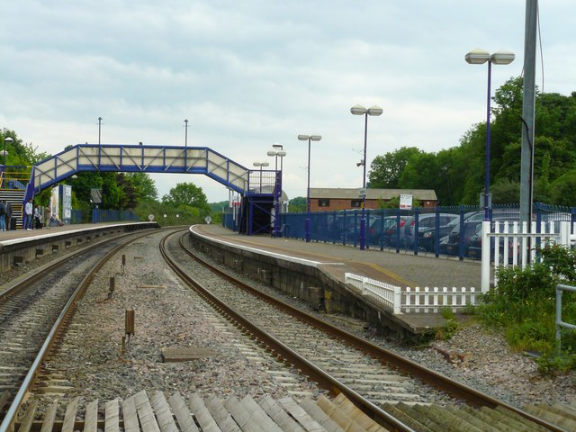
Photo: Chris Talbot, CC BY-SA 2.0.
Hungerford railway station is a railway station that serves the historic market town of Hungerford in Berkshire, England. It is 61 miles 43 chains measured from the zero point at London Paddington. Hungerford railway station is situated 1 mile southeast of Village Stocks.
Hungerford Town Hall
Town hall

Photo: Chris Talbot, CC BY-SA 2.0.
Hungerford Town Hall is a municipal building in the High Street, Hungerford, Berkshire, England. The town hall, which is the meeting place of Hungerford Town Council, is a Grade II listed building. Hungerford Town Hall is situated 1 mile south of Village Stocks.
Places in the Area
Nearby places include Leverton and Eddington.
Leverton
Hamlet
 Leverton is a small hamlet in West Berkshire, England, close to the border with Wiltshire and around 2 mi north-west of Hungerford.
Eddington
Hamlet
Eddington is a village in the civil parish of Hungerford in the West Berkshire district of Berkshire, England. It lies approximately 0.7 miles north-east from Hungerford, its nearest town and is divided from it by the River Kennet.
Lower Denford
Hamlet

Photo: Colin Bates, CC BY-SA 2.0.
Lower Denford is a hamlet in the civil parish of Kintbury in the English county of Berkshire. The settlement lies adjacent to the A4 road, and is located approximately 1 mile east of Hungerford.
Village Stocks
- Type: Historic site
- Description: architectural structure in Hungerford, West Berkshire, England, UK
- Categories: architectural structure, tourist attraction, and tourism
- Location: Hungerford, West Berkshire, England, United Kingdom, Britain and Ireland, Europe
- View on OpenStreetMap
Latitude
51.42824° or 51° 25′ 42″ northLongitude
-1.52205° or 1° 31′ 19″ westOpen location code
9C3WCFHH+75OpenStreetMap ID
node 13048939096OpenStreetMap feature
historic=yesWikidata ID
Q26507035
This page is based on OpenStreetMap, Wikidata, and Wikimedia Commons.
We’d love your help improving our open data sources. Thank you for contributing.
Satellite Map
Discover Village Stocks from above in high-definition satellite imagery.
Places with the Same Name
Discover other places named “Village Stocks”.
Notable Places Nearby
Highlights include The Shrubbery and Chilton Lodge.
Nearby Places
Explore places such as The Walled Garden and Toolstation.
England: Must-Visit Destinations
Delve into London, Manchester, Sheffield, and Leeds.
Curious Historic Sites to Discover
Uncover intriguing historic sites from every corner of the globe.
About Mapcarta. Data © OpenStreetMap contributors and available under the Open Database License". Text is available under the CC BY-SA 4.0 license, except for photos, directions, and the map. Photo: sidibousaid, CC BY 2.0.