Intendencia de Montevideo
Intendencia de Montevideo is a town hall in Municipio B, Montevideo Department. Intendencia de Montevideo is situated nearby to the scenic viewpoint Mirador Panorámico, as well as near the museum Museo de Historia del Arte.| Tap on a place to explore it |
Places of Interest Nearby
Highlights include Museo de Historia del Arte and Mercosur.
Museo de Historia del Arte
Museum

Photo: Elulene, CC BY-SA 4.0.
Museo de Historia del Arte is a museum.
Mercosur
Government office
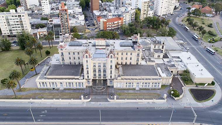
Photo: Fedaro, CC BY-SA 4.0.
The Southern Common Market is a South American trade bloc established by the Treaty of Asunción in 1991 and Protocol of Ouro Preto in 1994. Its full members are Argentina, Bolivia, Brazil, Paraguay, and Uruguay. Venezuela is a full member but has been suspended since 1 December 2016. Chile, Colombia, Ecuador, Guyana, Panama, Peru, and Suriname are associate countries. Mercosur is situated 1½ km southeast of Intendencia de Montevideo.
El Gaucho, Montevideo

Photo: Andreateletrabajo, CC BY 3.0.
El Gaucho, Montevideo is situated 170 metres northeast of Intendencia de Montevideo.
Places in the Area
Nearby places include Centro and Montevideo.
Centro
Suburb

Photo: Hoverfish, CC BY-SA 3.0.
Centro is a barrio of Montevideo, Uruguay. Being the city's downtown area, it forms part of its central business district, along with the neighboring areas of Cordón and Ciudad Vieja.
Montevideo

Photo: Ypsilon from Finland, CC0.
Montevideo is the capital city of Uruguay, on the east bank of the Rio de la Plata. Though sometimes overlooked beside nearby Buenos Aires, Montevideo is the cultural and political center of the country.
Palermo
Suburb

Photo: Hoverfish, CC BY-SA 3.0.
Palermo is a barrio of Montevideo, Uruguay. It borders Barrio Sur to the west, Cordón to the north and Parque Rodó to the east, while to the south it borders the coastline.
Intendencia de Montevideo
- Type: Town hall
- Category: government building
- Location: Municipio B, Montevideo Department, Uruguay, South America
- View on OpenStreetMap
Latitude
-34.90667° or 34° 54′ 24″ southLongitude
-56.18607° or 56° 11′ 10″ westOpen location code
48Q53RV7+8HOpenStreetMap ID
node 13099686920OpenStreetMap feature
amenity=townhall
This page is based on OpenStreetMap, Wikidata, and Wikimedia Commons.
We’d love your help improving our open data sources. Thank you for contributing.
Satellite Map
Discover Intendencia de Montevideo from above in high-definition satellite imagery.
Notable Places Nearby
Highlights include Mirador Panorámico and Intendencia de Montevideo.
Nearby Places
Explore places such as La Ibérica and Oriente.
Uruguay: Must-Visit Destinations
Delve into Montevideo, Salto, Colonia, and Punta del Este.
Curious Town Halls to Discover
Uncover intriguing town halls from every corner of the globe.
About Mapcarta. Data © OpenStreetMap contributors and available under the Open Database License". Text is available under the CC BY-SA 4.0 license, except for photos, directions, and the map. Photo: Elemaki, CC BY 3.0.