Boottochten Stael
Boottochten Stael is a station in Bruges, West Flanders, Flanders which is located on Katelijnestraat. Boottochten Stael is situated nearby to the bridge Mariabrug, as well as near Almshouse ‘Rooms Convent’.| Tap on a place to explore it |
Places of Interest Nearby
Highlights include Church of Our Lady and Groeningemuseum.
Church of Our Lady
Church

Photo: Wolfgang Staudt, CC BY 2.0.
The Church of Our Lady is a Roman Catholic church in Bruges, Belgium, dating mainly from the 13th, 14th and 15th centuries. Its 115.6-metre-high tower remains the tallest structure in the city and the third tallest brickwork church tower in the world. Church of Our Lady is situated 110 metres north of Boottochten Stael.
Groeningemuseum
Museum
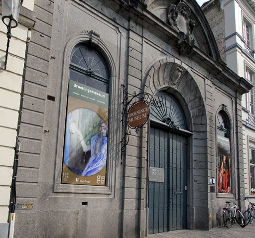
Photo: Le Fou, CC BY-SA 3.0.
The Groeningemuseum is a municipal museum in Bruges, Belgium, built on the site of the medieval Eekhout Abbey. It houses a collection of Flemish and Belgian painting covering six centuries, from Jan van Eyck to Marcel Broodthaers. Groeningemuseum is situated 260 metres north of Boottochten Stael.
Madonna of Bruges
Work of art

Photo: Jean-Pol GRANDMONT, CC BY 3.0.
The Madonna of Bruges is a marble sculpture by Michelangelo of the Virgin and Child. Michelangelo's depiction of the Madonna and Child differs significantly from earlier representations of the same subject, which tended to feature a pious Virgin smiling down on an infant held in her arms.
Places in the Area
Nearby places include Boeveriewijk and Ezelstraatkwartier.


Boottochten Stael
- Type: Station
- Address: Katelijnestraat 4, Brugge, 8000
- Categories: tourism, tourist attraction, passenger ship terminal, and transportation
- Location: Bruges, Arrondissement of Bruges, West Flanders, Flanders, Belgium, Benelux, Europe
- View on OpenStreetMap
Latitude
51.20365° or 51° 12′ 13″ northLongitude
3.2246° or 3° 13′ 29″ eastOperator
NV StealOpen location code
9F35663F+FROpenStreetMap ID
node 13119996820OpenStreetMap feature
amenity=ferry_terminalOpenStreetMap feature
public_transport=stationOpenStreetMap feature
tourism=attraction
This page is based on OpenStreetMap, Wikidata, and Wikimedia Commons.
We’d love your help improving our open data sources. Thank you for contributing.
Satellite Map
Discover Boottochten Stael from above in high-definition satellite imagery.
Notable Places Nearby
Highlights include Mariabrug and Almshouse ‘Rooms Convent’.
Nearby Places
Explore places such as Bellicious and Chocolaterie De Proeverie 6.
West Flanders: Must-Visit Destinations
Delve into Kortrijk, Ostend, Ypres, and Roeselare.
Curious Stations to Discover
Uncover intriguing stations from every corner of the globe.
About Mapcarta. Data © OpenStreetMap contributors and available under the Open Database License". Text is available under the CC BY-SA 4.0 license, except for photos, directions, and the map. Photo: MJJR, CC BY 3.0.