All India Imam Organization
All India Imam Organization is an office in Chanakya Puri, New Delhi, Delhi. All India Imam Organization is situated nearby to the mosque Masjid Kasturba Gandhi Marg, as well as near the government office Maharashtra Sadan.| Tap on a place to explore it |
Places of Interest Nearby
Highlights include India Gate and Agrasen Ki Baoli.
India Gate
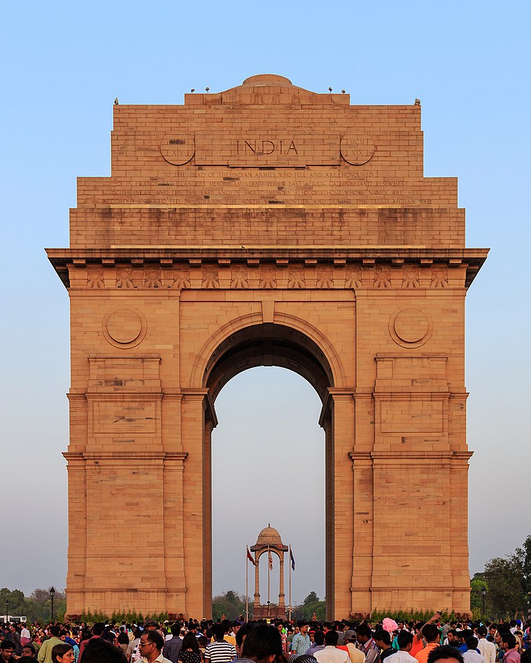 The India Gate is a war memorial located near the Rajpath on the eastern edge of the "ceremonial axis" of New Delhi. It stands as a memorial to 74,187 soldiers of the Indian Army who died between 1914 and 1921 in the First World War, in France, Flanders, Mesopotamia, Persia, East Africa, Gallipoli and elsewhere in the Near and the Far East, and the Third Anglo-Afghan War. India Gate is situated 780 metres south of All India Imam Organization.
Agrasen Ki Baoli
Archaeological site

Photo: Wikimedia, CC BY-SA 4.0.
Agrasen Ki Baoli is a 60-meter long and 15-meter wide historical stepwell in New Delhi, India. Located on Hailey Road, near Connaught Place, Jantar Mantar, it was designated a protected monument by the Archaeological Survey of India under the Ancient Monuments and Archaeological Sites and Remains Act of 1958. Agrasen Ki Baoli is situated 750 metres north of All India Imam Organization.
Jantar Mantar

Photo: Alejo2083, CC BY-SA 4.0.
Jantar Mantar in New Delhi is an observatory, designed to be used with the naked eye. It is one of five Jantar Mantar in India. "Jantar Mantar" means "instruments for measuring the harmony of the heavens". Jantar Mantar is situated 1¼ km northwest of All India Imam Organization.
Places in the Area
Nearby places include Eastern Delhi and Connaught Place.
Eastern Delhi

Photo: Wikimedia, CC BY-SA 3.0.
Eastern Delhi consists of three administrative districts: East Delhi, North East Delhi and Shahdara, which are all on the eastern bank of the Yamuna River. Akshardham is the most famous attraction in the district.
Connaught Place
Suburb

Photo: Kabi1990, CC BY-SA 3.0.
Connaught Place, also known as Rajiv Chowk or CP, is one of the main financial, commercial and business centres in New Delhi, Delhi, India. It houses the headquarters of several noted Indian firms and is a major shopping, nightlife, and tourist destination in New Delhi.
Raisina Hill
Neighborhood
 Raisina Hill, often used as a metonym for the seat of the Government of India, is an area of New Delhi, housing India's most important government buildings, including Rashtrapati Bhavan, the official residence of the President of India on a citadel and the Secretariat building, housing the Prime Minister's Office and several other important ministries.
All India Imam Organization
- Email: allindiaimamorganization@gmail.com
- Type: Office
- Location: Chanakya Puri, New Delhi, Delhi, Plains, India, South Asia, Asia
- View on OpenStreetMap
Latitude
28.61965° or 28° 37′ 11″ northLongitude
77.22714° or 77° 13′ 38″ eastOpen location code
7JWVJ69G+VVOpenStreetMap ID
node 13275078420OpenStreetMap feature
office=religion
This page is based on OpenStreetMap, Wikidata, and Wikimedia Commons.
We’d love your help improving our open data sources. Thank you for contributing.
Satellite Map
Discover All India Imam Organization from above in high-definition satellite imagery.
Notable Places Nearby
Highlights include Masjid Kasturba Gandhi Marg and Maharashtra Sadan.
Nearby Places
Explore places such as Travancore House and Civil Services Officers Institute.
Delhi: Must-Visit Destinations
Delve into Central Delhi, Indira Gandhi International Airport, South East Delhi, and South Delhi.
Curious Offices to Discover
Uncover intriguing offices from every corner of the globe.
About Mapcarta. Data © OpenStreetMap contributors and available under the Open Database License". Text is available under the CC BY-SA 4.0 license, except for photos, directions, and the map. Photo: Wikimedia, CC0.