Changi West
Changi West is a neighborhood in Singapore. Changi West is situated nearby to the neighborhood Loyang, as well as near Flora Drive.| Tap on a place to explore it |
Places of Interest
Highlights include The Changi Museum and Jewel Changi Airport.
The Changi Museum
Museum

Photo: Whoosises, CC BY-SA 3.0.
The Changi Chapel and Museum is a war museum dedicated to Singapore's history during the Second World War and the Japanese occupation of Singapore. After the British Army was defeated by the Imperial Japanese Army in the Battle of Singapore, thousands of prisoners of war were imprisoned in Changi prison camp for three and a half years.
Jewel Changi Airport
Shopping center
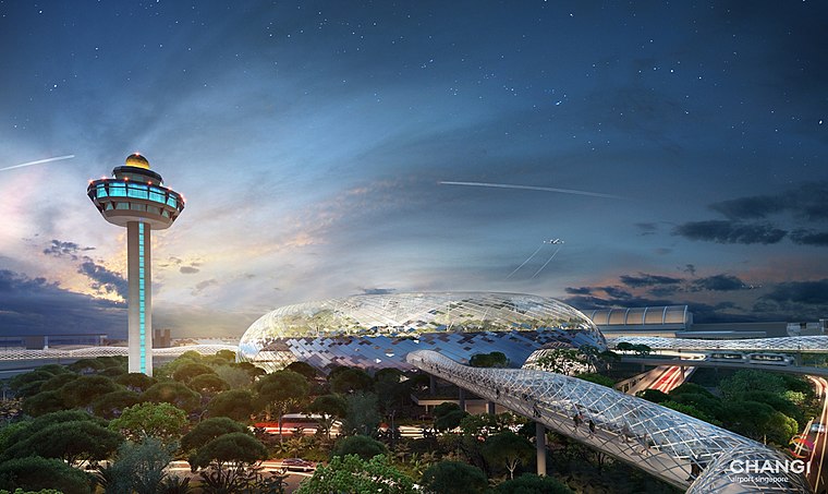 Jewel Changi Airport is a nature-themed entertainment and retail complex surrounded by and linked to one of the passenger terminals of Changi Airport in Singapore.
Changi Prison
Prison

Photo: Wikimedia, Public domain.
Changi Prison Complex, often known simply as Changi Prison, is a prison complex in the namesake district of Changi in the eastern part of Singapore. It is the largest prison in the country, covering an area of about 50 ha, and the oldest still in operation since the closure of Outram Prison in 1963.
Places in the Area
Nearby places include Loyang and Changi.
Loyang
Neighborhood
Loyang is a subzone region located in the town of Pasir Ris in the East Region of Singapore. The region consists of three subzones, Loyang West, Loyang East and Flora Drive.
Changi
Suburb

Photo: Calvin Teo, CC BY-SA 2.5.
Changi is a planning area located in the geographical region of Tanah Merah in the East Region of Singapore. Sharing borders with Pasir Ris and Tampines to the west, Changi Bay to the southeast, the South China Sea to the east and the Serangoon Harbour to the north. Changi is situated 2½ km southeast of Changi West.
East Coast

Photo: Sengkang, Copyrighted free use.
The East Coast of Singapore is largely residential and offers few sights as such; most visitors just cross it on their way from and to Changi Airport. For Singaporeans, on the other hand, the main attractions are 20 km of white sandy beach and the food: this is the home of many of Singapore's culinary icons.
Changi West
- Type: Neighborhood
- Category: locality
- Location: Singapore, Southeast Asia, Asia
- View on OpenStreetMap
Latitude
1.3656° or 1° 21′ 56″ northLongitude
103.97946° or 103° 58′ 46″ eastOpen location code
6PH59X8H+6QOpenStreetMap ID
node 13348031128OpenStreetMap feature
place=neighbourhood
This page is based on OpenStreetMap, Wikidata, and Wikimedia Commons.
We’d love your help improving our open data sources. Thank you for contributing.
Satellite Map
Discover Changi West from above in high-definition satellite imagery.
Localities in the Area
Explore places such as Loyang West and Flora Drive.
Notable Places Nearby
Highlights include Cosford Container Park and Lloyd Leas Work Release Camp.
Singapore: Must-Visit Destinations
Delve into Singapore Changi Airport, Sentosa and Harbourfront, North and West, and Riverside.
Curious Neighborhoods to Discover
Uncover intriguing neighborhoods from every corner of the globe.
About Mapcarta. Data © OpenStreetMap contributors and available under the Open Database License". Text is available under the CC BY-SA 4.0 license, except for photos, directions, and the map. Photo: Khairul Nizam, CC BY 2.0.