Team Framkallning
Team Framkallning is a shop in Stockholm, Stockholm Municipality, Stockholm County. Team Framkallning is situated nearby to the school Björngårdsskolan, as well as near the dōjō Sanshin Kan Karaté.| Tap on a place to explore it |
Places of Interest Nearby
Highlights include Stockholm City Museum and Stockholms södra.
Stockholm City Museum
Museum

Photo: Jordgubbe, CC BY-SA 2.0.
The Stockholm City Museum is a museum documenting, preserving and exhibiting the history of Stockholm. The museum is housed in Södra Stadshuset at Slussen on Södermalm. Stockholm City Museum is situated 500 metres northeast of Team Framkallning.
Stockholms södra
Railway station

Photo: Kalle1, Public domain.
Stockholm Södra is a railway station located in the Södermalm area of Stockholm, Sweden. Informally known as Södra Station, it is part of the Stockholm commuter rail network. Stockholms södra is situated 430 metres southwest of Team Framkallning.
Saint Eric’s Cathedral
Church
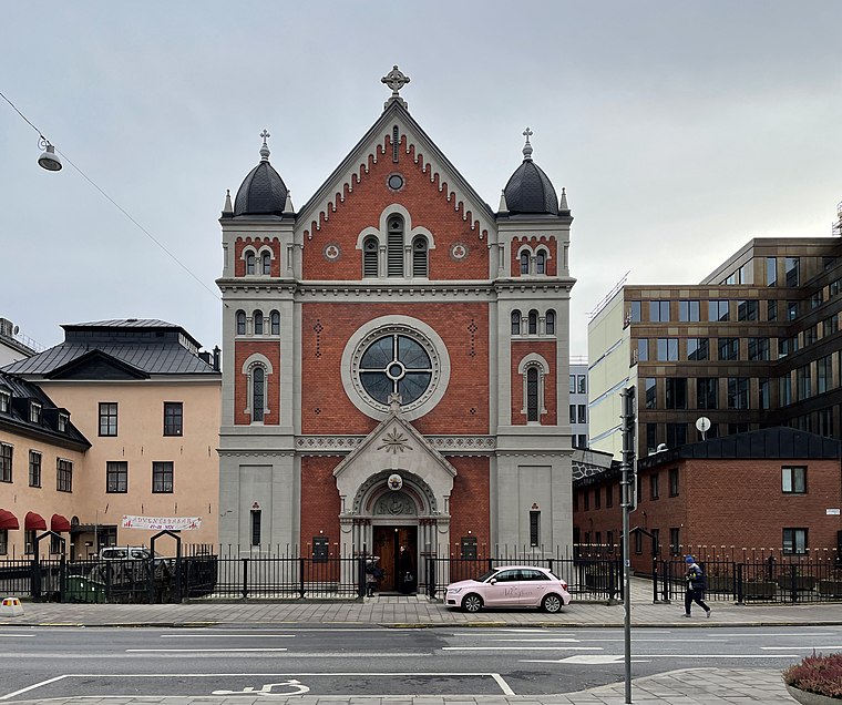
Photo: I99pema, CC BY-SA 4.0.
Saint Eric's Cathedral is a Catholic cathedral in Stockholm, Sweden. It is located on Södermalm, the southern part of central Stockholm. It was built in 1892 and was raised to the status of a cathedral in 1953, when the Catholic Diocese of Stockholm was created. Saint Eric’s Cathedral is situated 520 metres southeast of Team Framkallning.
Places in the Area
Nearby places include Södermalm and Gamla stan.
Södermalm

Photo: Wikimedia, CC BY-SA 3.0.
Södermalm is the southern borough of central Stockholm, consisting of the island of Södermalm proper, two smaller islands connected to it from the west, as well as the neighbourhood of Hammarby Sjöstad on the opposite bank of the Hammarby Sjö in the east, which is a redeveloped former industrial area that was transformed into a model sustainable residential community.
Gamla stan

Photo: Wikimedia, CC BY-SA 3.0.
Gamla stan pronounced gamlaˈstɑːn, the Old Town, also known as Staden mellan broarna is the Old Town in Stockholm, containing genuine cultural heritage, as well as tourist traps.
Zinkensdamm
Neighborhood

Photo: Wikimedia, Public domain.
Zinkensdamm is an area and a former manor in Södermalm in the Stockholm City Centre just east of Hornstull. The area was named after Frantz Zinck, who lived on the property for five years in the 1600s, though he never formally owned it.
Team Framkallning
- Opening hours:
Monday—Thursday: 8:00 AM—11:00 AM and noon—6:00 PM
Friday: 8:00 AM—11:00 AM and noon—5:00 PM - Type: Shop
- Location: Stockholm, Stockholms domkyrkoförs., Stockholm Municipality, Stockholm County, Svealand, Sweden, Nordic countries, Europe
- View on OpenStreetMap
Latitude
59.31643° or 59° 18′ 59″ northLongitude
18.06505° or 18° 3′ 54″ eastOpen location code
9FFW8388+H2OpenStreetMap ID
node 1488609344OpenStreetMap feature
shop=photo_development
This page is based on OpenStreetMap, Wikidata, and Wikimedia Commons.
We’d love your help improving our open data sources. Thank you for contributing.
Satellite Map
Discover Team Framkallning from above in high-definition satellite imagery.
Notable Places Nearby
Highlights include Björngårdsskolan and Sanshin Kan Karaté.
Nearby Places
Explore places such as Tonnys Cyklar and Sankt Göran.
Stockholm County: Must-Visit Destinations
Delve into Stockholm, Södermalm, Södertälje, and Norrmalm.
Curious Shops to Discover
Uncover intriguing shops from every corner of the globe.
About Mapcarta. Data © OpenStreetMap contributors and available under the Open Database License". Text is available under the CC BY-SA 4.0 license, except for photos, directions, and the map. Photo: Smiley.toerist, CC BY-SA 4.0.