Over Burrow Roman Fort
Over Burrow Roman Fort is the modern name given to a former Roman fort at Over Burrow, Lancashire in North West England. Today it is the site of the 18th-century country house Burrow Hall.| Tap on a place to explore it |
- Type: Archaeological site
- Description: Roman fort in Burrow-with-Burrow, Lancaster, England
- Also known as: “Calacum”, “Calavm”, “Galacum”, “Galacum Roman fort”, “Galacvm”, and “Roman fort and civil settlement, Over Burrow”
Places of Interest Nearby
Highlights include St Michael’s Church, Whittington and St John the Baptist’s Church, Tunstall.
St Michael’s Church, Whittington
Church

Photo: mauldy, CC BY-SA 2.0.
St Michael's Church is located in the settlement of Whittington, Lancashire, England. It is an active Anglican parish church in the deanery of Tunstall, the archdeaconry of Lancaster and the diocese of Blackburn. St Michael’s Church, Whittington is situated 1 mile west of Over Burrow Roman Fort.
St John the Baptist’s Church, Tunstall
Church

Photo: Karl and Ali, CC BY-SA 2.0.
St John the Baptist Church is located to the northeast of the village of Tunstall, Lancashire, England. It is an active Anglican parish church in the united benefice of East Lonsdale, in the deanery of Tunstall, the archdeaconry of Lancaster and the diocese of Blackburn. St John the Baptist’s Church, Tunstall is situated 1¼ miles south of Over Burrow Roman Fort.
Sellet Hall
Historic house

Photo: Karl and Ali, CC BY-SA 2.0.
Sellet Hall is a historic house, which is situated 1¼ miles northwest of Over Burrow Roman Fort.
Places in the Area
Nearby places include Kirkby Lonsdale and Cantsfield.
Kirkby Lonsdale

Photo: Nilfanion, CC BY-SA 4.0.
Kirkby Lonsdale is a town in Cumbria in England. Notable buildings include St Mary's Church, a Norman building with fine carved columns. The view of the River Lune from the churchyard is known as "Ruskin's View" after John Ruskin, who called it one of the loveliest in England.
Cantsfield
Hamlet
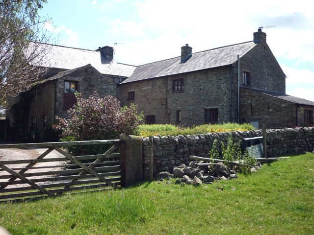
Photo: Wikimedia, CC BY-SA 2.0.
Cantsfield is a hamlet and civil parish in the City of Lancaster, in Lancashire, England, near the boundary with North Yorkshire. It is situated near the River Greta and on the A687 road near the junction with the A683. Cantsfield is situated 2 miles south of Over Burrow Roman Fort.
Masongill
Hamlet

Photo: Wikimedia, CC BY-SA 2.0.
Masongill is a small community on the western edge of the county of North Yorkshire, England. The village, in the Yorkshire Dales, lies near the border of Lancashire to the west, and the nearby hamlet of Ireby. Masongill is situated 3 miles east of Over Burrow Roman Fort.
Over Burrow Roman Fort
- Categories: castrum, historic site, tourist attraction, and tourism
- Location: Burrow-with-Burrow, Lancaster, Lancashire, North West England, England, United Kingdom, Britain and Ireland, Europe
- View on OpenStreetMap
Latitude
54.17698° or 54° 10′ 37″ northLongitude
-2.59097° or 2° 35′ 28″ westOpen location code
9C6V5CG5+QJOpenStreetMap ID
node 1574117112OpenStreetMap feature
historic=archaeological_siteWikidata ID
Q17640916
This page is based on OpenStreetMap, Wikidata, Wikimedia Commons, and Wikipedia.
We’d love your help improving our open data sources. Thank you for contributing.
Satellite Map
Discover Over Burrow Roman Fort from above in high-definition satellite imagery.
Notable Places Nearby
Highlights include Thackbarn Wood and Hollin Wood.
Nearby Places
Explore places such as The Highwayman and The Highwayman.
Lancashire: Must-Visit Destinations
Delve into Blackpool, Blackburn, Preston, and Burnley.
Curious Archaeological Sites to Discover
Uncover intriguing archaeological sites from every corner of the globe.
About Mapcarta. Data © OpenStreetMap contributors and available under the Open Database License". Text is available under the CC BY-SA 4.0 license, except for photos, directions, and the map. Description text is based on the Wikipedia page “Over Burrow Roman Fort”. Photo: Antiquary, CC BY 4.0.