Bolognetta
Bolognetta is a stop on Line C of the Rome Metro. It is located at the junction of Via Bolognetta and Via Motta Camastra, in the Roman frazione of Borgata Finocchio. The stop was renovated and it re-opened as part of the new Metro line on 9 November 2014.| Tap on a place to explore it |
Photo: Guybrush Threepwood, CC BY-SA 3.0.
- Type: Metro station
- Description: Rome Metro station
- Also known as: “Bolognetta metro station”
- Wheelchair access: yes
Places of Interest Nearby
Highlights include Finocchio and San Giovanni Maria Vianney.
Finocchio
Railway stop

Photo: Coudamcstolly, CC BY-SA 4.0.
Finocchio is a station of Line C of the Rome Metro. It is located at the intersection of Via di Rocca Cencia with Via Mandanici and Piazza Serrule, in the Roman frazione of Borgata Finocchio. Finocchio is situated 570 metres east of Bolognetta.
San Giovanni Maria Vianney
Church
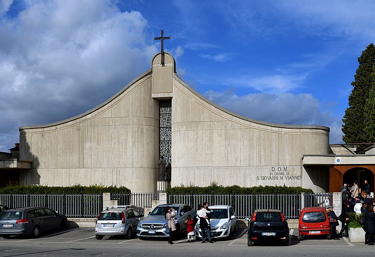
Photo: Paris Orlando, CC BY-SA 4.0.
The church of San Giovanni Maria Vianney is a church in Rome, the Borghesiana area, wide Monreale. It was built in the eighties, in the place of an earlier church built above ground in 1952, and solemnly consecrated by Cardinal Ugo Poletti on 4 November 1990… San Giovanni Maria Vianney is situated 1 km southwest of Bolognetta.
Borghesiana
Metro station

Photo: Livioandronico2013, CC BY-SA 4.0.
Borghesiana is a station of Line C of the Rome Metro. It is located between the Via Casilina and Via Biancavilla, in the Roman district of Borghesiana. Borghesiana is situated 1¼ km west of Bolognetta.
Places in the Area
Nearby places include Castelverde and Vermicino.
Castelverde
Village

Photo: Tobriand1987, Public domain.
Castelverde is a village, which is situated 4½ km north of Bolognetta.
Vermicino
Village
Vermicino is a village and civil parish of the Italian municipality of Frascati, in the Province of Rome, Lazio. In Italian language its name means "little worm", in an unused form. Vermicino is situated 5 km southwest of Bolognetta.
Torrenova
Village
Torrenova is the 16th zona of Rome, identified by the initials Z. XVI. It belongs partly to the Municipio VI and partly to the Municipio VII. Torrenova is situated 6 km west of Bolognetta.
Bolognetta
- Categories: elevated station, railway station, station, and transportation
- Location: Municipio Roma VI, Rome, Metropolitan Rome, Lazio, Central Italy, Italy, Europe
- View on OpenStreetMap
Latitude
41.86516° or 41° 51′ 55″ northLongitude
12.68093° or 12° 40′ 51″ eastOperator
ATACNetwork
ATACOpen location code
8FHJVM8J+39OpenStreetMap ID
node 1719260033OpenStreetMap feature
public_transport=stationOpenStreetMap feature
railway=stationOpenStreetMap attribute
wheelchair=yesWikidata ID
Q13919700
This page is based on OpenStreetMap, Wikidata, Wikimedia Commons, and Wikipedia.
We’d love your help improving our open data sources. Thank you for contributing.
Satellite Map
Discover Bolognetta from above in high-definition satellite imagery.
In Other Languages
From Dutch to Swedish—“Bolognetta” goes by many names.
- Dutch: “Bolognetta”
- Esperanto: “Bolognetta”
- French: “Bolognetta”
- German: “U-Bahnhof Bolognetta”
- Italian: “Bolognetta”
- Italian: “stazione di Bolognetta”
- Korean: “볼로녜타역”
- Lombard: “Bolognetta”
- Polish: “Bolognetta”
- Swedish: “Bolognetta”
Places with the Same Name
Discover other places named “Bolognetta”.
Notable Places Nearby
Highlights include Bolognetta and Sport Connection Club.
Nearby Places
Explore places such as Bolognetta and Bolognetta.
Rome: Must-Visit Destinations
Delve into North Centre, Modern Centre, Old Rome, and Vatican.
Curious Metro Stations to Discover
Uncover intriguing metro stations from every corner of the globe.
About Mapcarta. Data © OpenStreetMap contributors and available under the Open Database License". Text is available under the CC BY-SA 4.0 license, except for photos, directions, and the map. Description text is based on the Wikipedia page “Bolognetta”. Photo: Guybrush Threepwood, CC BY-SA 3.0.