Nehemya/Tsfanya
Nehemya/Tsfanya is a bus stop in Jerusalem District, Israel. Nehemya/Tsfanya is situated nearby to the college Tiferet Levi Yeshiva, as well as near the community center המרכז העולמי של חסידי גור.| Tap on a place to explore it |
Places of Interest Nearby
Highlights include Machane Yehuda Market and Damascus Gate.
Machane Yehuda Market
Marketplace

Photo: Sir kiss, Public domain.
Mahane Yehuda Market سوق محاني يهودا), often referred to as "The Shuk", is a marketplace in Jerusalem. Popular with locals and tourists alike, the market's more than 250 vendors sell fresh fruits and vegetables; baked goods; fish, meat and cheeses; nuts, seeds, and spices; wines and liquors; clothing and shoes; and housewares, textiles, and Judaica. Machane Yehuda Market is situated 1 km south of Nehemya/Tsfanya.
Damascus Gate
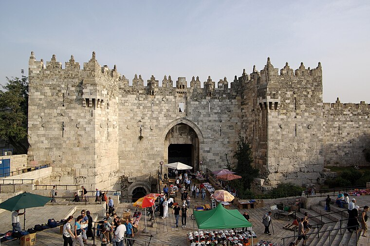
Photo: Berthold Werner, CC BY-SA 3.0.
The Damascus Gate is one of the main Gates of the Old City of Jerusalem. It is located in the wall on the city's northwest side and connects to a highway leading out to Nablus, which in the Hebrew Bible was called Shechem or Sichem, and from there, in times… Damascus Gate is situated 2 km southeast of Nehemya/Tsfanya.
Binyanei HaUma
Theater building

Photo: Wikimedia, CC BY-SA 3.0.
The International Convention Center, commonly known as Binyanei HaUma, is a concert hall and convention center in Giv'at Ram in Jerusalem, Israel. Binyanei HaUma is situated 1½ km southwest of Nehemya/Tsfanya.
Places in the Area
Nearby places include Tel Arza and HaBukharim.
Tel Arza
Suburb
Tel Arza is a Hareidi neighborhood in northern Jerusalem. It is bordered by Ezrat Torah on the west, Shikun Chabad on the south, the Bukharim quarter on the east, and Sanhedria on the north.
HaBukharim
Suburb
The Bukharan Quarter, also HaBukharim Quarter or Bukharim Quarter, is a neighborhood in the center of Jerusalem, Israel. The neighborhood was established by Bukharan Jews of the Old Yishuv.
Geula
Suburb

Photo: Yoninah, CC BY-SA 3.0.
Geula is a neighborhood in the center of Jerusalem, populated mainly by Haredi Jews. Geula is bordered by Zikhron Moshe and Mekor Baruch on the west, the Bukharim neighborhood on the north, Mea Shearim on the east and the Jerusalem city center on the south.
Nehemya/Tsfanya
- Type: Bus stop
- Category: transportation
- Location: Jerusalem District, Israel, Middle East, Asia
- View on OpenStreetMap
Latitude
31.79273° or 31° 47′ 34″ northLongitude
35.21584° or 35° 12′ 57″ eastOpen location code
8G3QQ6V8+38OpenStreetMap ID
node 1803064338OpenStreetMap feature
highway=bus_stopOpenStreetMap feature
public_transport=platform
This page is based on OpenStreetMap, Wikidata, and Wikimedia Commons.
We’d love your help improving our open data sources. Thank you for contributing.
Satellite Map
Discover Nehemya/Tsfanya from above in high-definition satellite imagery.
In Other Languages
From Arabic to Hebrew—“Nehemya/Tsfanya” goes by many names.
- Arabic: “نحميا/تْسفانيا”
- Hebrew: “נחמיה/צפניה”
Notable Places Nearby
Highlights include Tiferet Levi Yeshiva and המרכז העולמי של חסידי גור.
Nearby Places
Explore places such as Bar Ilan/Tzfania and Tsfanya/Nehemya.
Israel: Must-Visit Destinations
Delve into Tel Aviv, Carmel Range, Haifa, and Nazareth.
Curious Bus Stops to Discover
Uncover intriguing bus stops from every corner of the globe.
About Mapcarta. Data © OpenStreetMap contributors and available under the Open Database License". Text is available under the CC BY-SA 4.0 license, except for photos, directions, and the map. Photo: Bienchido, CC BY-SA 3.0.