Scapa Street / Skirsa Street
Scapa Street / Skirsa Street is a bus stop in Glasgow City, Scotland. Scapa Street / Skirsa Street is situated nearby to Garden of Remembrance, as well as near Garden of Reflection.| Tap on a place to explore it |
Places of Interest Nearby
Highlights include Gilshochill railway station and Western Necropolis.
Gilshochill railway station
Railway station

Photo: G Laird, CC BY-SA 2.0.
Gilshochill railway station is a railway station serving the Gilshochill, Maryhill and Cadder areas of Glasgow, Scotland. The station is located on the Maryhill Line, 31⁄4 miles north west of Glasgow Queen Street. Gilshochill railway station is situated 870 feet southwest of Scapa Street / Skirsa Street.
Western Necropolis
Cemetery

Photo: AlistairMcMillan, CC BY-SA 4.0.
Western Necropolis is a cemetery complex in Glasgow, Scotland located to the north of the city centre. As well as the actual Western Necropolis cemetery established in 1882, it is bordered by Lambhill Cemetery which opened in 1881, St Kentigern's Cemetery that opened in 1882, and Glasgow Hebrew Burial Ground founded in 1989. Western Necropolis is situated 1,500 feet north of Scapa Street / Skirsa Street.
Summerston railway station
Railway station

Photo: Stephen Sweeney, CC BY-SA 2.0.
Summerston railway station is a railway station serving the Summerston area of Glasgow, Scotland. It is located on the Maryhill Line, 4+1⁄4 miles northwest of Glasgow Queen Street. Summerston railway station is situated 2,800 feet west of Scapa Street / Skirsa Street.
Places in the Area
Nearby places include Cadder and Gilshochill.
Cadder
Suburb
Cadder is a neighbourhood in the north of Glasgow, Scotland. Within the Canal ward under Glasgow City Council, historically more closely associated with the Lambhill and Maryhill districts, it is located 5 kilometres north of Glasgow city centre, sited on the route of the Forth and Clyde Canal.
Gilshochill
Quarter
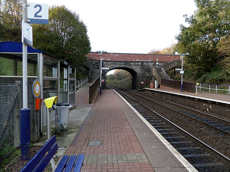
Photo: Rosser1954, CC BY-SA 4.0.
Gilshochill is located to the north west of Maryhill in the city of Glasgow, Scotland. Immediately north of Maryhill basin and Maryhill locks, it is the district where the Bowling and Port Dundas branches of the Forth and Clyde Canal meet at Stockingfield Junction.
Lambhill
Suburb

Photo: Alpin Stewart, CC BY-SA 2.0.
Lambhill is an area in the city of Glasgow, Scotland. It is situated north of the River Clyde, approximately 2 miles north of the city centre. Lambhill is a mainly residential area comprising both council and private housing.
Scapa Street / Skirsa Street
- Type: Bus stop
- Category: transportation
- Location: Glasgow City, Scotland, United Kingdom, Britain and Ireland, Europe
- View on OpenStreetMap
Latitude
55.89838° or 55° 53′ 54″ northLongitude
-4.27871° or 4° 16′ 43″ westOpen location code
9C7QVPXC+9GOpenStreetMap ID
node 2092122942OpenStreetMap feature
highway=bus_stopOpenStreetMap feature
public_transport=platform
This page is based on OpenStreetMap, Wikidata, and Wikimedia Commons.
We’d love your help improving our open data sources. Thank you for contributing.
Satellite Map
Discover Scapa Street / Skirsa Street from above in high-definition satellite imagery.
Notable Places Nearby
Highlights include Garden of Reflection and Garden of Remembrance.
Nearby Places
Explore places such as Skirsa Street / Fara Street and Scapa Street / Herma Street.
Scotland: Must-Visit Destinations
Delve into Edinburgh, Glasgow, Aberdeen, and Dundee.
Curious Bus Stops to Discover
Uncover intriguing bus stops from every corner of the globe.
About Mapcarta. Data © OpenStreetMap contributors and available under the Open Database License". Text is available under the CC BY-SA 4.0 license, except for photos, directions, and the map. Photo: Ritchyblack, FAL.