Nithsdale Road / Fleurs Avenue
Nithsdale Road / Fleurs Avenue is a bus stop in Glasgow City, Scotland. Nithsdale Road / Fleurs Avenue is situated nearby to Dumbreck railway station, as well as near Sherbrooke Mosspark Church.| Tap on a place to explore it |
Places of Interest Nearby
Highlights include Dumbreck railway station and Glasgow Rangers.
Dumbreck railway station
Railway station

Photo: Richard Webb, CC BY-SA 2.0.
Dumbreck railway station is a railway station in Dumbreck, a district of Glasgow, Scotland. The station is managed by ScotRail and lies on the Paisley Canal Line, 1+3⁄4 miles west of Glasgow Central, close to the M77 motorway. Dumbreck railway station is situated 350 feet northeast of Nithsdale Road / Fleurs Avenue.
Glasgow Rangers
Stadium
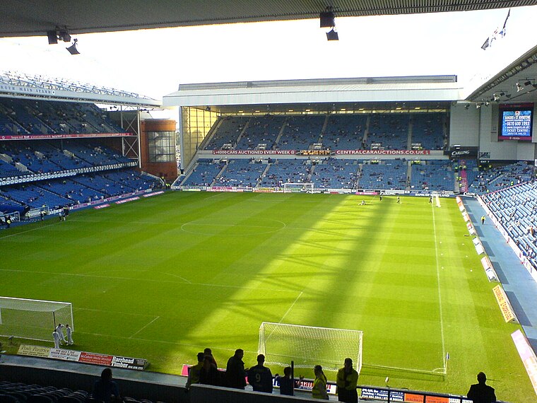
Photo: Archibald99, Public domain.
Ibrox Stadium is a football stadium on the south side of the River Clyde in the Ibrox area of Glasgow, Scotland. The home of Scottish Premiership team Rangers, Ibrox is the third-largest football stadium in Scotland, with an all-seated capacity of 51,700. Glasgow Rangers is situated 3,600 feet northwest of Nithsdale Road / Fleurs Avenue.
Sherbrooke Mosspark Church
Church

Photo: Stephen Sweeney, CC BY-SA 2.0.
Sherbrooke Mosspark Parish Church, also known as Sherbrooke St Gilbert's Church, is a congregation of the Church of Scotland serving the Pollokshields, Dumbreck and Mosspark areas on the south side of Glasgow, Scotland. Sherbrooke Mosspark Church is situated 710 feet east of Nithsdale Road / Fleurs Avenue.
Places in the Area
Nearby places include Dumbreck and Bellahouston.
Dumbreck
Suburb

Photo: Richard Webb, CC BY-SA 2.0.
Dumbreck is an area in the city of Glasgow, Scotland. It is situated south of the River Clyde. Dumbreck is a conservation area. The district is served by Dumbreck railway station. The only church in Dumbreck is St Leo the Great RC church.
Bellahouston
Suburb

Photo: Thomas Nugent, CC BY-SA 2.0.
Bellahouston is a district in the southwest of Glasgow. It is bordered by Dumbreck, Ibrox, Pollokshields, Craigton.
Pollokshields
Suburb

Photo: Peter Whatley, CC BY-SA 2.0.
Pollokshields is an area in the Southside of Glasgow, Scotland. Its modern boundaries are largely man-made, being formed by the M77 motorway to the west and northwest with the open land of Pollok Country Park and the Dumbreck neighbourhood beyond, by the…
Nithsdale Road / Fleurs Avenue
- Type: Bus stop
- Category: transportation
- Location: Glasgow City, Scotland, United Kingdom, Britain and Ireland, Europe
- View on OpenStreetMap
Latitude
55.84425° or 55° 50′ 39″ northLongitude
-4.30195° or 4° 18′ 7″ westOpen location code
9C7QRMVX+M6OpenStreetMap ID
node 2095342729OpenStreetMap feature
highway=bus_stopOpenStreetMap feature
public_transport=platform
This page is based on OpenStreetMap, Wikidata, and Wikimedia Commons.
We’d love your help improving our open data sources. Thank you for contributing.
Satellite Map
Discover Nithsdale Road / Fleurs Avenue from above in high-definition satellite imagery.
Notable Places Nearby
Highlights include Sherbrooke Castle Hotel, 11 Sherbrooke Avenue, Pollokshields, Glasgow and Bellahouston Academy.
Nearby Places
Explore places such as Nithsdale Road / Maxwell Drive and Dumbreck.
Scotland: Must-Visit Destinations
Delve into Edinburgh, Glasgow, Aberdeen, and Dundee.
Curious Bus Stops to Discover
Uncover intriguing bus stops from every corner of the globe.
About Mapcarta. Data © OpenStreetMap contributors and available under the Open Database License". Text is available under the CC BY-SA 4.0 license, except for photos, directions, and the map. Photo: Ritchyblack, FAL.