Salonkee
Salonkee is a hairdresser in Luxembourg, Central Luxembourg which is located on Avenue des Archiducs. Salonkee is situated nearby to the Bahá’í temple Centre Bahá’i, as well as near the government office Quattropole.| Tap on a place to explore it |
Places of Interest Nearby
Highlights include Stade Josy Barthel and Villa Louvigny.
Stade Josy Barthel
Stadium

Photo: Cornischong, CC BY-SA 1.0.
The Stade Josy Barthel is the former national stadium of Luxembourg, and the former home of the Luxembourg national football team. The stadium, which also hosted rugby union and athletics events, is located on route d'Arlon, in the Luxembourg City quarter of Belair. Stade Josy Barthel is situated 460 metres north of Salonkee.
Villa Louvigny
Public building

Photo: GilPe, CC BY-SA 3.0.
Villa Louvigny is a building in Luxembourg City, in southern Luxembourg, that served as the headquarters of Compagnie Luxembourgeoise de Télédiffusion, the forerunner of RTL Group. It is located in the Municipal Park, in the Ville Haute quarter of the city. Villa Louvigny is situated 770 metres east of Salonkee.
Villa Vauban
Museum
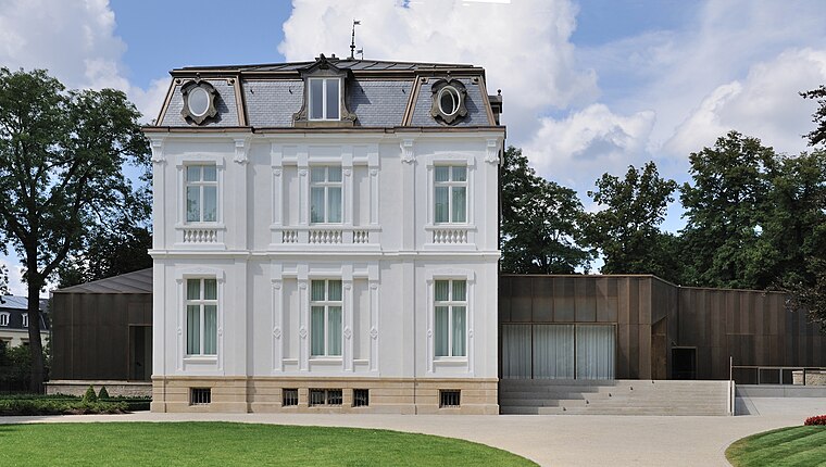
Photo: Cayambe, CC BY-SA 3.0.
The Villa Vauban is an art museum in Luxembourg City. It exhibits 18th- and 19th-century paintings acquired from private collections. Villa Vauban is situated 770 metres east of Salonkee.
Places in the Area
Nearby places include Rollingergrund-North Belair and Ville Haute.
Rollingergrund-North Belair
Suburb

Photo: Fliedermaus, CC BY-SA 3.0 lu.
Rollingergrund-North Belair is a district in north-western Luxembourg City, in southern Luxembourg. Within the modern district lies most of the former commune of Rollingergrund. As of 31 December 2024, the district had a population of 4,820 inhabitants.
Ville Haute
Suburb

Photo: GilPe, CC BY-SA 4.0.
The Ville-Haute is a district in central Luxembourg City, in southern Luxembourg. It is the historic center of Luxembourg City and is involved in its UNESCO World Heritage Site status.
Pfaffenthal
Suburb

Photo: Cayambe, CC BY-SA 3.0.
Pfaffenthal is a district in central Luxembourg City, in southern Luxembourg. The district owes its name to the German words Pfaffen, meaning monk, and Tal, meaning valley, as the area was once administered by the Benedictine Abbey in Altmunster.
Salonkee
- Type: Hairdresser
- Address: 16 Avenue des Archiducs, Luxembourg, 1135
- Category: shop
- Location: Luxembourg, Central Luxembourg, Luxembourg, Benelux, Europe
- View on OpenStreetMap
Latitude
49.61173° or 49° 36′ 42″ northLongitude
6.112° or 6° 6′ 43″ eastOpen location code
8FX8J466+MROpenStreetMap ID
node 2350019641OpenStreetMap feature
shop=hairdresser
This page is based on OpenStreetMap, Wikidata, and Wikimedia Commons.
We’d love your help improving our open data sources. Thank you for contributing.
Satellite Map
Discover Salonkee from above in high-definition satellite imagery.
Notable Places Nearby
Highlights include Centre Bahá’i and Quattropole.
Nearby Places
Explore places such as Takajo and Kopplabunz.
Luxembourg: Must-Visit Destinations
Delve into Schengen, Echternach, Ettelbruck, and Diekirch.
Curious Hairdressers to Discover
Uncover intriguing hairdressers from every corner of the globe.
About Mapcarta. Data © OpenStreetMap contributors and available under the Open Database License". Text is available under the CC BY-SA 4.0 license, except for photos, directions, and the map. Photo: Jjtkk, CC BY-SA 3.0.