Snack Izmir
Snack Izmir is a fast food restaurant in Bruges, West Flanders, Flanders. Snack Izmir is situated nearby to the library De Zorge, as well as near the town hall Sint-Kruis.| Tap on a place to explore it |
Places of Interest Nearby
Highlights include Heilige-Kruisverheffing-en-Sint-Jozefkerk and Kruispoort.
Heilige-Kruisverheffing-en-Sint-Jozefkerk
Church
 Heilige-Kruisverheffing-en-Sint-Jozefkerk is a church, which is situated 270 metres east of Snack Izmir.
Kruispoort
City gate
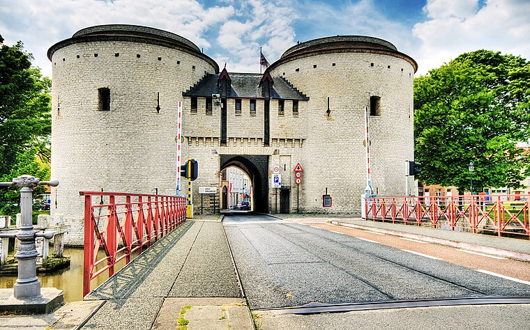
Photo: Wolfgang Staudt, CC BY 2.0.
Kruispoort is a city gate, which is situated 440 metres west of Snack Izmir.
Belfry

Photo: Jean-Pol GRANDMONT, CC BY-SA 4.0.
The Belfry of Bruges is a medieval bell tower in the centre of Bruges, Belgium. One of the city's most prominent symbols, the belfry formerly housed a treasury and the municipal archives and served as an observation post for spotting fires and other dangers. Belfry is situated 1½ km west of Snack Izmir.
Places in the Area
Nearby places include Sint-Gillis and Sint-Jozef.

Sint-Jozef
Neighborhood
 Sint-Jozef is a quarter in Bruges, which is the capital of the Flemish province of West Flanders, in Belgium.

Snack Izmir
- Type: Fast food restaurant
- Cuisine: kebab
- Categories: food and restaurant
- Location: Bruges, Arrondissement of Bruges, West Flanders, Flanders, Belgium, Benelux, Europe
- View on OpenStreetMap
Latitude
51.21325° or 51° 12′ 48″ northLongitude
3.24639° or 3° 14′ 47″ eastOpen location code
9F35667W+7HOpenStreetMap ID
node 2358822556OpenStreetMap feature
amenity=fast_foodOpenStreetMap attribute
cuisine=kebab
This page is based on OpenStreetMap, Wikidata, and Wikimedia Commons.
We’d love your help improving our open data sources. Thank you for contributing.
Satellite Map
Discover Snack Izmir from above in high-definition satellite imagery.
Places with the Same Name
Discover other places named “Snack Izmir”.
Notable Places Nearby
Highlights include De Zorge and Sint-Kruis.
Nearby Places
Explore places such as VDK Spaarbank and Isola Bella.
West Flanders: Must-Visit Destinations
Delve into Kortrijk, Ostend, Ypres, and Roeselare.
Curious Fast Food Restaurants to Discover
Uncover intriguing fast food restaurants from every corner of the globe.
About Mapcarta. Data © OpenStreetMap contributors and available under the Open Database License". Text is available under the CC BY-SA 4.0 license, except for photos, directions, and the map. Photo: MJJR, CC BY 3.0.