La P’tite Folie
La P’tite Folie is a restaurant in Edinburgh, Scotland which is located on Randolph Place. La P’tite Folie is situated nearby to the church West Register House, as well as near the health club Gym On The Square.| Tap on a place to explore it |
- Type: Restaurant
- Cuisine: French
- Address: 9 Randolph Place, Edinburgh, EH3 7TE
Places of Interest Nearby
Highlights include Edinburgh Castle and Bute House.
Edinburgh Castle
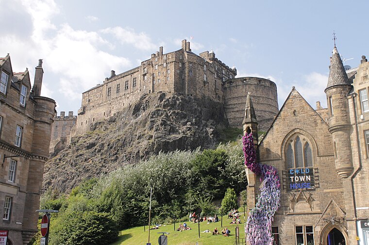
Photo: Stephencdickson, CC BY-SA 4.0.
Edinburgh Castle is a historic castle in Edinburgh, Scotland. It stands on Castle Rock, which has been occupied by humans since at least the Iron Age. There has been a royal castle on the rock since the reign of Malcolm III in the 11th century, and the castle continued to be a royal residence until 1633. Edinburgh Castle is situated 2,200 feet southeast of La P’tite Folie.
Bute House
Government office

Photo: Scottish Government, CC BY 2.0.
Bute House is the official residence and workplace of the first minister of Scotland. Located at 6 Charlotte Square in the New Town of Edinburgh, it is the central house on the north side of the square and was designed by Robert Adam. Bute House is situated 520 feet northeast of La P’tite Folie.
West Register House
Church

Photo: Enric, CC BY-SA 4.0.
West Register House is a building of the National Records of Scotland, located on Charlotte Square in Edinburgh, Scotland, United Kingdom. The building was constructed between 1811 and 1814 as St George's Church and converted to its current purpose as a records office between 1964 and 1970.
Places in the Area
Nearby places include Moray Estate and West End.
Moray Estate
Neighborhood

Photo: Brian McNeil, CC BY 3.0.
The Moray Estate, also known as the Moray Feu, is an early 19th century building venture attaching the west side of the New Town, Edinburgh. Built on an awkward and steeply sloping site, it has been described as a masterpiece of urban planning.
West End
Suburb

Photo: Richard Webb, CC BY-SA 2.0.
The West End is an affluent district of Edinburgh, Scotland, which along with the rest of the New Town and Old Town forms central Edinburgh, and Edinburgh's UNESCO World Heritage Site.
Dean Village
Suburb

Photo: 瑞丽江的河水, CC BY-SA 4.0.
Dean Village is a former village immediately northwest of the city centre of Edinburgh, Scotland. It is bounded by Belford Road to the south and west, Belgrave Crescent Gardens to the north and below the Dean Bridge to the east.
La P’tite Folie
- Category: food
- Location: Edinburgh, Scotland, United Kingdom, Britain and Ireland, Europe
- View on OpenStreetMap
Latitude
55.9515° or 55° 57′ 5″ northLongitude
-3.20987° or 3° 12′ 36″ westOpen location code
9C7RXQ2R+H3OpenStreetMap ID
node 2414850523OpenStreetMap feature
amenity=restaurantOpenStreetMap attribute
cuisine=french
This page is based on OpenStreetMap, Wikidata, and Wikimedia Commons.
We’d love your help improving our open data sources. Thank you for contributing.
Satellite Map
Discover La P’tite Folie from above in high-definition satellite imagery.
Places with the Same Name
Discover other places named “La P’tite Folie”.
Notable Places Nearby
Highlights include Gym On The Square and Taipei Representative Office in the UK.
Nearby Places
Explore places such as Le Di-Vin and Tsunami Axis.
Edinburgh: Must-Visit Destinations
Delve into Old Town, New Town, West Edinburgh, and Leith.
Curious Restaurants to Discover
Uncover intriguing restaurants from every corner of the globe.
About Mapcarta. Data © OpenStreetMap contributors and available under the Open Database License". Text is available under the CC BY-SA 4.0 license, except for photos, directions, and the map. Photo: Wikimedia, CC BY 3.0.