NHS Ordsall Health Surgery
NHS Ordsall Health Surgery is a clinic in Salford, England which is located on Phoebe Street. NHS Ordsall Health Surgery is situated nearby to Primrose Hill Primary School and Children’s Centre, as well as near the school Oasis Academy MediaCityUK.| Tap on a place to explore it |
- Opening hours: Monday—Friday 8:00 AM—6:30 PM
- Email: salccg.ordsallhealthsurgery@nhs.net
- Type: Clinic
- Address: 118 Phoebe Street, Salford, M5 3PH
- Wheelchair access: yes
Places of Interest Nearby
Highlights include Old Trafford and Oasis Academy MediaCityUK.
Old Trafford
Stadium
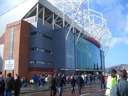
Photo: Wikimedia, Public domain.
Old Trafford is a football stadium in Old Trafford, Greater Manchester, England, and is the home of Manchester United. With a capacity of 74,197, it is the largest club football stadium in the United Kingdom, and the eleventh-largest in Europe. Old Trafford is situated 1 mile southwest of NHS Ordsall Health Surgery.
Oasis Academy MediaCityUK
School
Oasis Academy MediaCityUK is a co-educational secondary school for 11-16 year olds in Salford Quays, Salford, Greater Manchester, England. The school is an academy run by Oasis Community Learning, a multi-academy trust. Oasis Academy MediaCityUK is situated 590 feet northwest of NHS Ordsall Health Surgery.

Places in the Area
Nearby places include Ordsall and Salford Quays.
Ordsall
Suburb

Photo: Nev1, CC BY-SA 3.0.
Ordsall is an inner city suburb of Salford, Greater Manchester, England. The population at the 2011 census was 14,194. It lies chiefly to the south of the A57 road, close to the River Irwell, the main boundary with the city of Manchester, Salford Quays and Manchester Ship Canal, which divides it from Stretford.
Salford Quays
Suburb

Photo: Frombowen, CC BY-SA 4.0.
Salford Quays is an area of Salford, Greater Manchester, England, near the end of the Manchester Ship Canal. Previously the site of Manchester Docks, it faces Trafford across the canal.
The Quays
 The Quays covers the four areas of Salford Quays, Trafford Wharf, Old Trafford and Trafford Centre to the west of Manchester city centre.
NHS Ordsall Health Surgery
- Category: health care
- Location: Salford, England, United Kingdom, Britain and Ireland, Europe
- View on OpenStreetMap
Latitude
53.47421° or 53° 28′ 27″ northLongitude
-2.28202° or 2° 16′ 55″ westOperator
National Health ServiceOpen location code
9C5VFPF9+M5OpenStreetMap ID
node 2415203981OpenStreetMap feature
amenity=clinicOpenStreetMap feature
healthcare=clinicOpenStreetMap attribute
wheelchair=yes
This page is based on OpenStreetMap, Wikidata, and Wikimedia Commons.
We’d love your help improving our open data sources. Thank you for contributing.
Satellite Map
Discover NHS Ordsall Health Surgery from above in high-definition satellite imagery.
Notable Places Nearby
Highlights include Primrose Hill Primary School and Children’s Centre and St Joseph’s RC Primary School.
Nearby Places
Explore places such as K’s Chemist and Trafford Road/Phoebe Street.
England: Must-Visit Destinations
Delve into London, Manchester, Sheffield, and Leeds.
Curious Clinics to Discover
Uncover intriguing clinics from every corner of the globe.
About Mapcarta. Data © OpenStreetMap contributors and available under the Open Database License". Text is available under the CC BY-SA 4.0 license, except for photos, directions, and the map. Photo: Craig Sunter, CC BY 2.0.