Ayvansaray Pier
Ayvansaray Pier is a station in Historical Peninsula, Istanbul. Ayvansaray Pier is situated nearby to Cemil Meriç Parkı, as well as near the historic building İskender Bey Fountain.| Tap on a place to explore it |
Photo: Wikimedia, CC BY-SA 3.0.
- Type: Station
- Description: pier in Fatih District
- Also known as: “Ayvansaray”
Places of Interest Nearby
Highlights include Golden Horn and Walls of Blachernai.
Golden Horn

Photo: VikiPicture, CC BY-SA 3.0.
The Golden Horn is the district of Istanbul surrounding the banks of the body of water of the same name, which is a bay of the Bosphorus along its western, European coast.
Walls of Blachernai

Photo: -jha-, CC BY-SA 3.0.
The walls of Constantinople are a series of defensive stone walls that have surrounded and protected the city of Constantinople since its founding as the new capital of the Roman Empire by Constantine the Great. Walls of Blachernai is situated 560 metres southwest of Ayvansaray Pier.
Atik Mustafa Pasha Mosque
Mosque

Photo: Wikimedia, CC BY-SA 4.0.
Atik Mustafa Pasha Mosque is a former Eastern Orthodox church in Istanbul, converted into a mosque by the Ottomans. In Çember Sokak in the neighbourhood of Ayvansaray, in the district of Fatih, Istanbul, it lies just inside the walled city at a short distance from the Golden Horn, at the foot of the sixth hill of Constantinople. Atik Mustafa Pasha Mosque is situated 250 metres south of Ayvansaray Pier.
Places in the Area
Nearby places include Hasköy and Sütlüce.
Hasköy
Quarter

Photo: VikiPicture, CC BY-SA 3.0.
Hasköy is a trading and residential district on the northern bank of the Golden Horn in Beyoğlu, Istanbul, Turkey. It includes the neighbourhoods of Keçeci Piri, Piri Paşa, and Halıcıoğlu, and parts of Camiikebir and Sütlüce.
Sütlüce
Suburb

Photo: Moonik, CC BY-SA 3.0.
Sütlüce is a neighbourhood in the municipality and district of Beyoğlu, Istanbul Province, Turkey. Its population is 12,736. It is on the eastern bank of the Golden Horn.
Eyüpsultan
Town
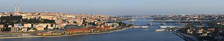
Photo: Ggia, CC BY-SA 3.0.
Eyüpsultan or Eyüp is a municipality and district of Istanbul Province, Turkey. Its area is 228 km2, and its population is 422,913. The district extends from the Golden Horn all the way to the shore of the Black Sea.
Ayvansaray Pier
- Categories: pier, wharf, passenger ship terminal, and transportation
- Location: Historical Peninsula, Istanbul, Turkey, Middle East, Asia
- View on OpenStreetMap
Latitude
41.04081° or 41° 2′ 27″ northLongitude
28.94486° or 28° 56′ 42″ eastOpen location code
8GHC2WRV+8WOpenStreetMap ID
node 27609492OpenStreetMap feature
amenity=ferry_terminalOpenStreetMap feature
public_transport=stationWikidata ID
Q113407620
This page is based on OpenStreetMap, Wikidata, and Wikimedia Commons.
We’d love your help improving our open data sources. Thank you for contributing.
Satellite Map
Discover Ayvansaray Pier from above in high-definition satellite imagery.
In Other Languages
“Ayvansaray Pier” goes by many names.
- Turkish: “Ayvansaray İskelesi”
Notable Places Nearby
Highlights include Ayvansaray and Cemil Meriç Parkı.
Nearby Places
Explore places such as Ayvansaray and Şehit Tolga Ecebalın.
Turkey: Must-Visit Destinations
Delve into Istanbul, Edirne, Ankara, and Izmir.
Curious Stations to Discover
Uncover intriguing stations from every corner of the globe.
About Mapcarta. Data © OpenStreetMap contributors and available under the Open Database License". Text is available under the CC BY-SA 4.0 license, except for photos, directions, and the map. Photo: Wikimedia, CC BY-SA 3.0.