Kitchens Defined
Kitchens Defined is a shop in Edinburgh, Scotland which is located on Dalry Road. Kitchens Defined is situated nearby to the railway station Haymarket, as well as near Dalry Road Post Office.| Tap on a place to explore it |
- Type: Shop
- Also known as: “Development Direct”
- Address: 51-53-55-57 Dalry Road, Edinburgh
Places of Interest Nearby
Highlights include Haymarket railway station and Edinburgh Castle.
Haymarket railway station
Railway station

Photo: Wikimedia, CC BY-SA 2.0.
Haymarket railway station is the second largest railway station in Edinburgh, Scotland, after Waverley railway station. The station serves as a major commuter and long-distance destination, located near the city centre, in the West End. Haymarket railway station is situated 420 feet northwest of Kitchens Defined.
Edinburgh Castle
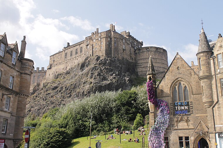
Photo: Stephencdickson, CC BY-SA 4.0.
Edinburgh Castle is a historic castle in Edinburgh, Scotland. It stands on Castle Rock, which has been occupied by humans since at least the Iron Age. There has been a royal castle on the rock since the reign of Malcolm III in the 11th century, and the castle continued to be a royal residence until 1633. Edinburgh Castle is situated 3,900 feet northeast of Kitchens Defined.
St Mary’s Cathedral
Church

Photo: Farwestern, CC BY 3.0.
The Cathedral Church of Saint Mary the Virgin, commonly known as St Mary's Episcopal Cathedral, is a cathedral of the Scottish Episcopal Church in the West End of Edinburgh, Scotland; part of the worldwide Anglican Communion. St Mary’s Cathedral is situated 1,600 feet north of Kitchens Defined.
Places in the Area
Nearby places include Haymarket and Dalry.
Haymarket
Suburb

Photo: Kim Traynor, CC BY-SA 3.0.
Haymarket is an area of Edinburgh, Scotland. It is in the west of the city centre and is the junction of several main roads, notably Dalry Road, Corstorphine Road, and Shandwick Place. Haymarket contains a number of pubs, cafés and restaurants.
Dalry
Suburb

Photo: Kim Traynor, CC BY-SA 3.0.
Dalry is an area of the Scottish capital city of Edinburgh. It is located close to the city centre, between Haymarket and Gorgie. The area is now primarily residential.
Fountainbridge
Suburb

Photo: Kim Traynor, CC BY-SA 3.0.
Fountainbridge is a former industrial district in Edinburgh, Scotland, a short distance west of the Old Town. It is built around the street of the same name, which begins at the West Port and continues towards Gorgie and Dalry.
Kitchens Defined
Latitude
55.94444° or 55° 56′ 40″ northLongitude
-3.21779° or 3° 13′ 4″ westOpen location code
9C7RWQVJ+QVOpenStreetMap ID
node 2781855184OpenStreetMap feature
shop=kitchen
This page is based on OpenStreetMap, Wikidata, and Wikimedia Commons.
We’d love your help improving our open data sources. Thank you for contributing.
Satellite Map
Discover Kitchens Defined from above in high-definition satellite imagery.
Notable Places Nearby
Highlights include Haymarket and Dalry Road Post Office.
Nearby Places
Explore places such as Barbers Fifty Nine and Stitch Express.
Edinburgh: Must-Visit Destinations
Delve into Old Town, New Town, West Edinburgh, and Leith.
Curious Shops to Discover
Uncover intriguing shops from every corner of the globe.
About Mapcarta. Data © OpenStreetMap contributors and available under the Open Database License". Text is available under the CC BY-SA 4.0 license, except for photos, directions, and the map. Photo: Wikimedia, CC BY 3.0.